THE SECRETARY OF DEFENSE
WASHINGTON, THE DISTRICT OF COLUMBIA
25 MAY 1994
MEMORANDUM FOR SECRETARIES OF THE MILITARY DEPARTMENTS
SUBJECT: Persian Gulf War Health Issues
Chairman Shalikashvili and I want to ensure that sick Persian Gulf veterans receive the best care available. The attached memorandum provides essential reassurances about that.
The memorandum makes the following points: veterans who believe they have health problems resulting from service in the Gulf should come forward for examination and treatment; our forces were not attacked by chemical or biological weapons; and military personnel are not barred, by any classification restrictions, from discussing issues related to their health.
Please ensure that this memorandum is distributed through all the channels necessary to reach the men and women who served in Operations Desert Shield and Desert Storm. Edwin Dora, Under Secretary of Defense for Personnel and Readiness, is coordinating the Department's efforts to deal with the health effects of Persian Gulf service.
Willliam J. Perry
Attachment: As stated
United States Dual-Use Exports to Iraq and Their Impact
Re: United States Dual-Use Exports to Iraq and Their Impact
![]() by admin » Thu Dec 17, 2015 5:51 pm
by admin » Thu Dec 17, 2015 5:51 pm
- admin
- Site Admin
- Posts: 36184
- Joined: Thu Aug 01, 2013 5:21 am
Re: United States Dual-Use Exports to Iraq and Their Impact
![]() by admin » Thu Dec 17, 2015 5:52 pm
by admin » Thu Dec 17, 2015 5:52 pm
UNITED STATES CENTRAL COMMAND
7115 SOUTH BOUNDARY BOULEVARD
MACDILL AIR FORCE BASE, FLORIDA 33621-5101
13 NOV 1994
CCJI
Subject: Freedom of Information Act (FOIA) Request 94-41
Mr. James Tuite
Committee on Banking, Housing, and Urban Affairs
Washington, DC 20510-6075
Dear Mr. Tuite:
This is in reply to a FOIA request from Senator Riegle dated 16 March 1994 and received within the US Central Command 5 October 1994, as a referral from the Defense Intelligence Agency (DIA). The DIA searched and forwarded nine documents responsive to your request for our review and release determination.
These documents were reviewed and determined to be properly classified and should not be reclassified at this time. They will be returned to the Secretary of the Senate, Office of Security, U.S. Capitol S-407, Washington, DC to Mr. Michael DiSilvestro's attention.
If you have additional questions regarding your request, Major Blaisdell or Senior Master Sergeant Skinner are the command's FOIA Officers and stand ready to assist you. You may reach them at (813) 828-6679/6685. When calling, please refer to FOIA number 94-41.
Sincerely,
Robert J. Martinelli
Colonel, United States Air Force
Director of Manpower, Personnel and Administration
Enclosures
- admin
- Site Admin
- Posts: 36184
- Joined: Thu Aug 01, 2013 5:21 am
Re: United States Dual-Use Exports to Iraq and Their Impact
![]() by admin » Thu Dec 17, 2015 5:52 pm
by admin » Thu Dec 17, 2015 5:52 pm
UNDER SECRETARY OF DEFENSE
4000 DEFENSE PENTAGON
WASHINGTON, DC. 20301-4000
[ILLEGIBLE] 22, 1994
Honorable Donald W. Riegle, Jr.
Chairman
Committee on Banking, Housing, and Urban Affairs
United States Senate
Washington, DC 20510
Dear Mr. Chairman:
Thank you for your letter of July 29, requesting information to questions from the May 25 Hearing on U.S. Dual Use Exports to Iraq and their Impact on the Health of Gulf War Veterans. An interim response was sent on August 31. The unclassified responses are enclosed. They also are being provided to Ms. Kelly Cordes as requested. The classified responses have been forwarded under separate correspondence in accordance with the appropriate security procedures.
I want to thank you for your concern and interest. Please be assured that we are deeply committed to the health and well being of our current and former Service members and it remains a top priority within the Department.
Sincerely,
Edwin Dorn
Enclosure:
As stated
cc:
Honorable Alfonse D'Amato
Ranking Republican
Ms. Kelly Cordes
Chief Clerk
- admin
- Site Admin
- Posts: 36184
- Joined: Thu Aug 01, 2013 5:21 am
Re: United States Dual-Use Exports to Iraq and Their Impact
![]() by admin » Thu Dec 17, 2015 5:57 pm
by admin » Thu Dec 17, 2015 5:57 pm
Department of Veterans' Affairs Gulf War Syndrome Registry
BREAKDOWN BY STATE OF RESIDENCE OF THE 12,774 VETERANS WHO HAVE TAKEN THE GULF WAR REGISTRY EXAM THROUGH MARCH 1994.
State of Residence/ Frequency / Percent of Total
Alabama / 979 / 7.7
Arizona / 258 / 2.0
Arkansas / 253 / 2.0
California / 439 / 3.4
Colorado / 161 / 1.3
Connecticut / 37 / 0.3
Delaware / 88 / 0.7
District of Columbia / 62 / 0.5
Florida / 612 / 4.8
Georgia / 923 / 7.2
Hawaii / 35 / 0.3
Idaho / 26 / 0.2
Illinois / 317 / 2.5
Indiana / 356 / 2.8
Iowa / 196 / 1.5
Kansas / 152 / 1.2
Kentucky / 352 / 2.8
Louisiana / 184 / 1.4
Maine / 146 / 1.1
Maryland / 145 / 1.1
Massachusetts / 149 / 1.2
Michigan / 277 / 2.2
Minnesota / 205 / 1.6
Mississippi / 233 / 1.8
Missouri / 319 / 2.5
Montana / 76 / 0.6
Nebraska 140 / 1.1
Nevada / 27 / 0.2
New Hampshire / 162 / 1.3
New Jersey / 119 / 0.9
New Mexico / 150 / 1.2
New York / 509 / 4.0
North Carolina / 827 / 6.5
North Dakota / 82 / 0.6
Ohio / 269 / 2.1
Oklahoma / 191 / 1.5
Oregon / 185 / 1.4
Pennsylvania / 589 / 4.6
Puerto Rico / 48 / 0.4
Rhode Island / 34 / 0.3
South Carolina / 238 / 1.9
South Dakota / 61 / 0.5
Tennessee / 410 / 3.2
Texas / 630 / 4.9
Utah / 10 / 0.1
Vermont / 85 / 0.7
Virginia / 248 / 1.9
Washington / 66 / 0.5
West Virginia / 69 / 0.5
Wisconsin / 630 / 4.9
Wyoming / 13 / 0.1
- admin
- Site Admin
- Posts: 36184
- Joined: Thu Aug 01, 2013 5:21 am
Re: United States Dual-Use Exports to Iraq and Their Impact
![]() by admin » Thu Dec 17, 2015 5:58 pm
by admin » Thu Dec 17, 2015 5:58 pm
QUESTIONS SUBMITTED BY HONORABLE DONALD W. RIEGLE, Jr., CHAIRMAN COMMITTEE ON BANKING, HOUSING, AND URBAN AFFAIRS
US. DUAL USE EXPORTS TO IRAQ AND THEIR IMPACT ON THE HEALTH OF GULF WAR VETERANS
MAY 25, 1994
QUESTIONS FOR HONORABLE EDWIN DORN, UNDERSECRETARY OF DEFENSE FOR PERSONNEL AND READINESS
[Senator Riegle letter of July 29, 1994]
Questions from Chairman Riegle
Q.1. Was the Department of Defense intelligence apparatus aware of the items exported to Iraq by the United States which were converted to use in the Iraqi chemical, biological, and nuclear programs prior to the Persian Gulf War? Provide specific details.
A.1. During the earlier years associated with Iraq's build-up of its scientific, industrial and military capabilities, Iraq was neither a proscribed nation to be denied military critical technology, nor an enemy. The U.S. intelligence community is forbidden from monitoring the activities of U.S. citizens and U.S. companies. Consequently, very little was known by the Intelligence Community about U.S. exports of technology with military potential, particularly to a non-proscribed non-enemy nation, unless it was informed of such exports by the Department of Commerce. During 1980-1994, the Department of Commerce requested that DoD review only 16 dual-use export cases. Of these, only two were forwarded to the DIA for technical review. They involved computers and signal processing equipment. DIA recommended denial in both cases. DIA was aware of the illegal export of thiodiglycol to Iraq by the Baltimore company Alcolac. DIA assisted customs and the FBI in their investigation and successful prosecution of that company.
Q.2. Were Iraqi chemical and biological facilities among the priority targets hit by Coalition bombers during the first days of the air war?
A.2. Yes. Some Iraqi chemical and biological (CB) facilities were priority targets and were among the first attacked on and around the first days of the air war. However, not every CB target was attacked during the first days. CB targets were themselves prioritized, generally by the intelligence community, then more specifically by the CENTCOM operators and were attacked accordingly. Generally speaking, CB targets were attacked at the very beginning of the air war and throughout the air campaign.
Q.3. Were U.S. national laboratories contacted prior to the war and requested to assess the danger from the fallout of bombing Iraqi chemical, biological, and nuclear facilities? What was their advice?
A.3. Yes. The Defense Nuclear Agency (DNA) was tasked to assess the danger of fallout from bombed Iraqi facilities. An example of the analysis conducted by the DNA to assess the effects of bombing Nuclear, Biological and Chemical (NBC) facilities is at Attachment A. DNA developed the Army's Automated NBC Information System (ANBACIS II) to analyze the impact of NBC contamination on military operations. Downwind hazard modeling of the southern-most storage facilities showed that chemical contamination would not occur beyond 11.1 kilometers downwind from the target The closest U.S. or coalition forces to the Ash Shuyabah chemical storage area, the southern- most storage facility, was 150 kilometers. It is for this reason that reports of detections associated with downwind drift from bombed chemical facilities are discounted.
The ability to quickly communicate with DNA analysts was available to commanders in the Gulf theater. Twenty-one sets of ANBACIS II equipment, which provided direct communications between the units and DNA stateside, were distributed in theater. Over 600 plots were run by DNA at the request of deployed units conducting vulnerability analysis. A complete description of the ANBACIS system and how it functioned during the war is at Attachment A.
Q.4. Did the automatic chemical agent detection alarms begin to sound more often with the initiation of the Coalition bombings? If so, why?
A.4 . Yes, because more alarms (M8A1 and M43A1) were placed into operation after the bombing started to prepare for any Iraqi retaliation. The M8A1 alarm is activated during normal preventive maintenance checks and services (see Attachment B). The M43A1 (the detector component of the M8A1 system) will alarm when exposed to heavy concentrations of rocket propellant smoke, screening smoke, signaling smoke, when engine exhaust is present or when a nuclear explosion occurs. Additionally, the alarm will sound in response to a heavy concentration of tobacco smoke, burning rubber, insecticides, low battery indicator, or strong percussion such as proximity to heavy vehicles or incoming artillery. There were approximately 13,200 M8A1 detectors in theater.
Q.5. Was the M8A1 automatic chemical agent detection alarm deployed during the Persian Gulf War sufficiently sensitive to detect chronic harmful exposure levels of chemical nerve agents?
A.5. Yes, for levels known to be harmful. The M8A1 G and VX agent sensitivity of 0.1- 0.2 mg-min/m3 is more than adequate to warn ground troops against known effects of chemical warfare nerve agents. The only known effect of nerve agents at this level of concentration is pinpointed pupils.
Q.6. Was the M256 or M256A 1 chemical agent kit sufficiently sensitive to detect harmful exposure levels of chemical blister agents that could pose a chronic exposure hazard to U.S. troops?
A.6. The M256A1 sensitivity to blister agents is as follows, and is more than adequate to warn ground troops against blister agent vapors: H - 2mg-min/m3; L - 9mg-min/m3; and CX - 3mg-min/m3. Normally, the first indication of exposure to blister agent vapors is eye injury, which occurs at concentrations of 100-200 Ct(mg-min/m3). Incapacitating blisters occur at 2,000 Ct(mg-min/m3), death through respiratory inhalation at 1,500 Ct(mg-min/m3).
Q.7. Were positive readings ever obtained with the M256 or M256A1 test kits? Include in your answer positive results obtained even though another tests may have been conducted with negative results? How long does it take to conduct an M256A1 kit reading?
A.7. The records reviewed to date have not revealed any positive readings. M256A1 response time for G,V,H,L,CX, and CK is 15 minutes and 25 minutes for AC.
G - non-persistent nerve agent
V - persistent nerve agent
H - mustard or blister agent
L - lewisite or blister agent
CX - choking agent
CK - blood agent
AC - blood agent
Q.8. Does the M 17 gas mask provide sufficient protection against chronic exposures to chemical nerve agents? If so, why is it not recommended for use in chronic exposures in U.S. Army material safety data sheets?
A.8. Yes. Material safety data sheets provide information on safe storage, handling, and disposal of all types of chemical and hazardous materials throughout the civilian, military, and industrial communities. The particular material safety data sheets contained in the Senate Banking Committee Report of May 25, 1994, for example, refer to protective measures required by personnel working in production, depot storage, and transportation of chemical material. The possible exposure to very high concentrations of chemicals and hazardous materials in these circumstances requires levels of protection that far exceed tactical military requirements. Soldiers require protection from field concentrations of chemical agents and therefore, soldier protective equipment must be more rugged, have greater wear time, require less logistic support, and be light weight equipment available for non-tactical applications. For example, the soldier's field mask must allow for weapons sighting, be worn in extreme hot and extreme cold, and be strong enough to survive infantry operations.
Q.9. Did the U.S. have field automatic biological detection monitors deployed during the Persian Gulf War? What type? Are they currently deployed with U.S. field units?
A.9. Automatic biological detection monitors did not exist during the Gulf War. All biological detectors were manually operated. Biological agent detection units are deployed based upon theater requirements. If a biological detection requirement is identified in the force structure, a chemical corps units will be deployed for that purpose. See response to Question #14 for additional information.
Q.10. Are all biological agents lethal? Isn't it true that one biological warfare strategy is to debilitate your adversary's capabilities and another is to overload his medical facilities?
A.10. No. Not all biological warfare agents arc lethal; some are only lethal if untreated, while others are almost always lethal, even with medical treatment. Incapacitating BW agents could be used to debilitate an adversary's capabilities and to overload his medical facilities. Bacillus anthracis, botulinum toxin, francisella, tularensis, and yersinia pestis are examples of lethal agents; VEE virus, Q fever, and staph enterotoxin B are examples of incapacitating agents. The BW strategy statement is true for chemical, biological, nuclear, unconventional and conventional warfare strategy.
Q.11. Are the presence of sick or dead animals and birds one of the indicators U.S. forces are trained to look for as a warning of biological warfare agent use?
A.11. Yes. The BW usage indicators are:
• Occurrence of acutely ill military and civilian patients
• Illness reflects an unusual or impossible agent for the geographical area
• Unusual distribution of disease
• Unexplained number of dead animals
• Direct evidence - discovery of munitions with BW agents.
Q.12. Might widespread flu-like symptoms also be an indicator of biological warfare use?
A.12. Possibly. Some infectious agents known to be potential biological warfare agents can have flu-like symptoms as part of an early infection. Examples would be Q-fever, anthrax, tularemia, and plague. Flu-like symptoms including fever, sore throat, cough, loss of appetite, and muscle and joint aches are very non-specific and are generally the first signs of any infectious disease, many of which are not known to be biological warfare threats.
Q.13. Were there outbreaks of antibiotic resistant strains of E. Coli and Shigella among U.S. forces during Operations Desert Shield or Desert Storm? How were the bacteria identified? Given the nature of the U.S. exports to the Iraq Atomic Energy Commission- were full DNA polymerase chain reaction studies conducted on these bacteria to determine if they were genetically modified?
A.13. Approximately 40-60% of enterotoxigenic E. Coli and 20-80% of Shigella spp. isolated from cases of acute diarrhea among Desert Shield troops were resistant to standard antibiotics used to treat diarrhea (trimethoprim-sulfamethoxazole, tetracycline, and ampicillin). Resistance was determined using standard laboratory methods. It was also found that no single strain of bacterial eoteropathogen was Che cause of antibiotic resistant diarrhea. Enteric bacterial pathogens resistance to commonly used antibiotics were expected at the beginning of Operation Desert Shield because resistant organisms are now found throughout the world. particularly in developing and tropical countries. Antibiotic resistant enteric disease pathogens can be obtained easily in nearly all tropical/developing countries by using simple, standard laboratory techniques; genetic modification is not necessary. Full DNA PCR analysis was not performed because there was nothing unusual or unexpected about the resistant, bacterial, enteropathogens identified in the Gulf.
Q.14. What procedures did the U.S. follow to determine whether U.S. forces were exposed to biological agents? What was tested for? What were the results of those tests?
A.14. Several years before the Gulf War, U.S. Army scientists and engineers crafted a contingency plan to address the threat of biological agents. A monoclonal antibody technology detector test was developed. When intelligence sources assessed Iraq as having a potential anthrax and botulinum toxin offensive capability, ten thousand anthrax and ten thousand botulinum toxin test kits were distributed throughout the Desert Storm theater of action. No biological warfare agents were identified during Operation Desert Shield/Storm.
Fifteen teams from the 9th Chemical Company were deployed by the U.S. Army to collect and analyze samples using the XM-2, a high volume air sampler, which operates by collecting aerosolized material into a liquid solution. That solution can be analyzed to determine the presence of biological warfare materials.
The Naval Medical Research and Development Command deployed the Navy Forward Laboratory (NFL) to perform the biological warfare (BW) analysis mission. Other NFL missions during Operation Desert Shield/Storm were:
• Laboratory diagnosis of clinical cases of infectious diseases
• Threat assessment of infectious diseases of military importance
• Detection capability for potential BW agents
• Public health assistance to the local population and to the Coalition Forces
The NFL consisted of four microbiologists, two infectious disease specialists, and two advanced lab technologists. The laboratory had the capability to test for the following agents: salmonella, shigella, vibrio cholera, V. parhemonlyticus, escherichia coli, salmonella typi, s. partyphi, yersinia enterocolitica, Cryptosporidium, rotavirus, legionella pneumophila, yersina pestis, francisilla tularensis, neiserra meningitidis, N. gonorrhoeae, straphylococcus, streptococcus, hepatitis A,B, hantaan viriis, chlamydia, intestinal ova and parasites, malaria parasites, sandfly fever (Naples and Sicilian), West Nile fever. Rift Valley Fever, Crimean-Congo Hemorrhagic fever, sindbis, dengue, Q fever, murine typhus, Mediterranean spotted fever, mycoplasma pneumoniae, adenovirus, parainfluenza virus 1,2,3, influenza vims A&B, respiratory syncitial virus, steptococcus pyogenes, neisseria meningitidis, and streptococcus pneumoniae.
The NFL could perform specific BW agent identification by performing bacterial culture and antibiotic sensitivities, indirect fluorescent antibody assay, antigen capture ELISA, IgM and IgG capture ELISA, and polymerase chain reaction assay. The labs conducted analysis of dead animals, verified air samples collected by the biological sampling teams, tested water and soil for agents and toxins, and analyzed the rapid field assays.
In addition, U.S. Army specialists provided B W consultation and hands-on assistance to allies in the British, Canadian, and French armies. Great Britain and Canada developed and deployed reconnaissance vehicles, each of which included an air sampler, a particle sizer and various antibody-based tests (immunoassays). The French also deployed antibody-based tests for BW agents with assistance from U.S. Array specialists from Fort Detrick and Edgewood Arsenal.
Q.15. Were any biological agents or materials capable of being used to cause disease or other illnesses discovered by the U.S. or any other Coalition forces in Iraq, Kuwait, or Saudi Arabia? What were those materials?
A.15. No such materials were found by U.S. or Coalition forces.
Q.16. Were any Iraqi vaccines discovered or did interviews of enemy prisoners of war. or others, reveal what biological warfare-related materials the Iraqis had defended against?
A.16. No.
Q.17. Did Iraq have a biological warfare program that appeared to be offensive in nature?
A.17. Yes. The classified package provides additional information and is being addressed by separate correspondence.
Q.18. In the spring of 1993. the United Nations Special Commission on Iraq sent a biological warfare inspection team to Iraq under the leadership of U.S. Army Colonel David Franz (USAMRIID). One of the sites visited was a facility of the Iraqi Atomic Energy Commission which also does biological research. Was Colonel Franz briefed on the nature of the materials shipped by the United States to Iraq prior to the war to alert him that genetic research may have been being conducted.
A.18. Prior to his leading the UNSCOM BW inspection team in March 1993, COL Franz was briefed on the major microbial strains which the Iraqis had obtained from the ATCC before the war. Observation and questions regarding genetic research are part of the biological inspection modus operandi, with or without a prebrief on the subject. Mr. Jim Tuite showed COL Franz a list in the spring of 1994 that included genetic constructs and vectors. During COL Franz's visits to Tuwaitha in March 1993 and May/June 1994, he found no evidence of prohibited research, genetic or classical, ongoing, planned or having been conducted at Tuwaitha.
Q.19. Were chemical munitions or binary precursor materials capable of being used in chemical warfare discovered in any area of Iraq, Kuwait, or Saudi Arabia before, during, or after the war by U.S. forces, U.S. civilian personnel, or other coalition participants?
A. 19. Classified response received from the Department of Defense [deleted]. Response archived in U.S. Senate Committee on Banking, Housing, and Urban Affairs files.
Q.20. What evidence, if any, is there concerning the forward deployment of chemical and biological warfare agents or weapons prior to or during the Persian Gulf conflict? What evidence, if any, is there of Iraqi attempts to avoid destruction of chemical or biological warfare agents or weapons by coalition bombings? For example, transshipment activity just prior to the initiation of the air war from chemical production facilities such as Samarra. Al Muthanna, Habbaniyah, or others?
A.20. Classified response received from the Department of Defense [deleted]. Response archived in U.S. Senate Committee on Banking, Housing, and Urban Affairs files.
Q.21. What evidence, if any, exists of Iraqi chemical and biological warfare defensive measures during or prior to the Persian Gulf War?
A. 21. Iraq claims it did not have a dedicated BW defensive program. Iraq distributed drugs for the treatment of nerve and mustard exposure to at least some of its Republican Guard Divisions. There was an effort to outfit their troops with chemical protective gear; this usually consisted of a gas mask, gloves, boots, simple poncho, and individual chemical agent antidote kits. Additionally, decontamination stations were established throughout Iraq.
Q.22. What evidence, if any, exists of Iraqi command instructions to use chemical weapons prior to or during the war?
A.22. Classified response received from the Department of Defense [deleted]. Response archived in U.S. Senate Committee on Banking, Housing, and Urban Affairs files.
Q.23. Were any Iraqi chemical units in Iraq or Kuwait located or reported on by U.S. or coalition sources during Operation Desert Shield or Desert Storm? Explain?
A.23. Classified response received from the Department of Defense [deleted], response archived in U.S. Senate Committee on Banking, Housing, and Urban Affairs files.
Q.24. In the Department of Defense's final report to Congress on the Conduct of the Persian Gulf War, it was reported that 88 Scud launches were detected. Saddam Hussein has claimed to have launched at least 93 Scuds. Can you explain the discrepancy? Were any Scud missiles launched by Iraq against Turkey or any other location other than Israel or Saudi Arabia? Were U.S. forces and dependent personnel in Turkey ever ordered into MOPP gear?
A.24. The Department records indicate a total of 88 SCUD launches against Israeli and Saudi Arabian targets only. Iraq only launched SCUD missiles against Israel and Saudi Arabia. We cannot explain the discrepancy between Saddam's claim to have launched at least 93 SCUDs. All units, which were in a SCUD missile threat area, responded with chemical defense standard operating procedures. Commanders at the lowest level of command determined the appropriate level of chemical defense for their units. No specific records were maintained at the unit level to indicate the use of MOPP gear. The Department is not aware of any personnel in Turkey being ordered into MOPP gear.
Q.25. What targets were Spirit 1, Spirit 2, and Spirit 3 (U.S. Air Force AC-1 30 Spectre gunships) directed against on January 31, 1991? Were any of the targets of their mission - in which one of these aircraft was shot down in the battle for Khafji - suspected of being chemical, biological, or nuclear weapons? What were the results of those missions?
A.25. Spirits 01, 02, and 03 (three AC-130H aircraft) were launched sequentially to provide close air support to U.S. ground forces engaged in and around the town of Khafji. Spirits 01 and 02 attacked the following targets: a truck park, a border post, a radio station and antenna, and a radar site with associated Armored Personnel Carriers (APCs) and personnel. Spirit 03 attacked similar targets; however, the specific targets cannot be determined because the aircraft was shot down during the mission. Spirit 03 was attacking a free rocket over ground (FROG) missile site just before it was shot down. None of the targets were NBC. The results of the attacks indicate minimal damage inflicted on the truck park, border post, and radio station. Three APCs were destroyed around and near the radar site.
Q.26. Did Iraq conduct test firings of Scuds or other short or medium range ballistic missiles during Operation Desert Shield? What was the assessed purpose for these tests since Iraq already had extensive knowledge of the capabilities of Scud missiles?
A.26. Classified response received from the Department of Defense [deleted]. Response archived in U.S. Senate Committee on Banking, Housing, and Urban Affairs files.
Q.27. Did Iraq have the capability to deliver biological weapons via ground- based aerosol generators, aircraft, helicopters, or FAW missiles? Do they have any other means of delivering biological weapons?
A.27. Classified response received from the Department of Defense [deleted]. Response archived in U.S. Senate Committee on Banking, Housing, and Urban Affairs files.
Q.28. What was the Defense Intelligence Agency evaluation of Iraq's chemical and biological weapons programs and delivery means prior to, during, and after the Persian Gulf War? What delivery means were within range of coalition forces at the beginning of the air war and by the end of the ground war?
A.28. Classified response received from the Department of Defense [deleted]. Response archived in U.S. Senate Committee on Banking, Housing, and Urban Affairs files.
Q.29. Did any Iraqi aircraft, helicopter, or FAW ground-to-ground missile ever penetrate Saudi airspace or areas over U.S. naval forces in the Persian Gulf? Include in your answer any areas where chemical and biological materials could have been distributed to contaminate U.S. forces even if not directly over Saudi Arabia.
A.29. The Iraqi Scud attacks on Saudi Arabia, Bahrain and Israel were highly publicized. The Iraqi offensive air capability was destroyed the first day of the ground war. There was no release of chemical or biological materials.
Q.30. Describe the evolution of Iraq's battlefield employment of chemical weapons during the Iran-Iraq war, did Iraq's ability to use these weapons improve over the course of the war?
A.30. Classified response received from the Department of Defense [deleted]. Response archived in U.S. Senate Committee on Banking, Housing, and Urban Affairs files.
Q.31. What chemical and biological agents were assessed to be in the Iraqi operational inventories and test inventories prior to the Persian Gulf War?
A.31. Classified response received from the Department of Defense [deleted]. Response archived in U.S. Senate Committee on Banking, Housing, and Urban Affairs files.
Q.32. Were U.S. or NATO chemical protective overgarments or masks vulnerable to specific types of chemical or biological agents in the Iraqi inventory?
A. 32. There were no equipment vulnerabilities specific to the Iraqi chemical agent inventory. No biological warfare agents were identified during Operation Desert Shield/Storm.
Q. 33. Was U.S. and NATO detection equipment capable of detecting Iraqi biological agents? Explain.
A.33. Yes, although U.S. Forces did not deploy any NATO biological detection equipment to Southwest Asia. See Response to Question #14 for information on U.S. equipment .
Q.34. What evidence exists, if any, to indicate that Iraq deployed chemical mines in the Kuwaiti theater of operations?
A.34. There is no evidence that Iraq deployed chemical mines in the KTO. In fact, over 350,000 Iraqi mines have been found and removed from Kuwait, none of which were chemical mines.
Q.35. Did Iraq deploy any chemical units or establish any chemical decontamination sites in the Kuwaiti or Iraqi theater of operations - or in the disputed territories?
A.35. Classified response received from the Department of Defense [deleted]. Response archived in U.S. Senate Committee on Banking, Housing, and Affairs files.
Q.36. Which country provided the chemical Scud warheads to Iraq that were later located by the UN inspections? If by another country, how many of these warheads were initially provided? Did Iraq also manufacture its own?
A.36. Classified response received from the Department of Defense [deleted]. Response archived in U.S. Senate Committee on Banking, Housing, and Affairs files.
Q.37. Was the former Soviet Union ever suspected of providing chemical or biological warfare training to Iraqi officers either in Iraq, the Soviet Union, or any other country? Explain.
A.37. Classified response received from the Department of Defense [deleted]. Response archived in U.S. Senate Committee on Banking, Housing, and Affairs files].
Q.38. Is the Department of Defense aware of any Soviet assistance to the Iraqis in setting up any chemical training center or production facility in Iraq? Explain.
A.38. Classified response received from the Department of Defense [deleted]. Response archived in U.S. Senate Committee on Banking, Housing, and Affairs files.
Q.39. Did the United States ever provide chemical or biological warfare training to Iraqi officers either in Iraq, the United States, or any other country. Explain.
A.39. At one time the United States and Iraq had friendly relationships, to include military exchange programs. Iraqi officers attended the U.S. Army Chemical School until the 1978-1979 timeframe.
Q.40. Is there any classified or unclassified information that would indicate any exposures to or detections of chemical or biological agents?
A.40. Other than the Czech detections in January of 1991, which have been discussed at length during testimony and other questions for the record, there is no information, classified or unclassified, which would indicate any exposures to or valid confirmed detections of chemical or biological agents. There were many, probably thousands, of false chemical alarms experienced by the Coalition; however, no alarm ever was verified using follow-up confirmation procedures. This includes the French reports, the FOX vehicle moving into Kuwait, and the bunker incident after the war.
As with the alleged CW detections, there are some unsubstantiated reports that allege exposure to BW agents. However, despite concerted efforts, Coalition assets were not able to confirm any of these reports.
Q.41. Is there any classified or unclassified information that would indicate the discovery of any chemical, biological, radiological or nuclear warfare related materials by U.S. or Coalition forces before, during, or after the Persian Gulf War?
A.41. There is no information, classified or unclassified, that would indicate the discovery of any chemical, biological, radiological or nuclear warfare related materials by the U.S. or Coalition forces before, during or after the Persian Gulf War. After the war, Iraq declared and turned over nuclear, biological, and chemical (NBC) related material to the UN inspection teams. None of the material which Iraq turned over to the UN teams originated within the KTO. The Department is not aware of any information derived from the UN inspections that supports any allegation that Iraqi NBC programs are responsible for the Gulf War Syndrome, either directly or indirectly. See classified package for additional information.
Q.42. In February 1994, the Defense Science Advisory Board contacted the Banking Committee and asked for a list of witnesses to what may have been direct Iraqi attacks. A representative list of at least one person from each event noted was sent to the Department of Defense. It has been reported back to my office by a number of those interviewed by the DoD that rather than ask substantive questions about the events and to locate other witnesses, high-ranking military officers called these individuals to inform them that they were mistaken and to tell them that Iraq had did not have the ability to initiate these types of attacks -- which, of course, is false.
Under whose personal direction are these officers operating -- and if operating without direction, what corrective or disciplinary steps will DoD take to ensure that in the future, Department representatives ask for information, rather than try to convince these veterans that they didn't see what they reported?
A.42 . In support of the Defense Science Board on Gulf War Health Effects charter, the Department interviewed several Persian Gulf veterans, including witnesses who related their Persian Gulf experiences to the staff members for the Committee on Banking, Housing, and Urban Affairs. The majority of the individuals, who were interviewed, expressed their appreciation that the DoD was taking an interest in them and answering their questions concerning Operation Desert Storm chemical and biological issues. No disciplinary action is planned.
Q.43. What is the role of your office in the investigation into the exposure of U.S. forces to chemical and/or biological materials during Operation Desert Shield and Desert Storm?
A.43. The Office of the Secretary of Defense (Health Affairs), OASD(HA) is responsible for all Persian Gulf health-related issues. The Office of the Assistant to the Secretary of Defense (Atomic Energy), OASTD(AE), provided administrative support and researched material for the Defense Science Board Task on Gulf War Health Effects. OATSD(AE) has also reviewed records, collected information and interviewed personnel with knowledge of chemical/biological operations related to the Gulf War and provided information to a variety of individuals and agencies. OATSD(AE) is assisting OASD(HA) in implementing a Desert Storm records research and declassification effort.
Q.44. What role, if any did the Defense Nuclear Agency play in the destruction of hazardous materials during or after the Persian Gulf War?
A.44. DNA did not have a role in the destruction of hazardous materials during or after the Persian Gulf War. DNA personnel did participate in identification of stocks and their location, and identification of nuclear production facilities.
Follow Up (Q.45). Did any personnel from the Defense Nuclear Agency or working under the direction of the Defense Nuclear Agency or any other Department of Defense element participate in the destruction of chemical, biological or nuclear materials before, during, or after the war. If so, what materials were destroyed?
A.45. No DNA personnel or anyone working under the direction of DNA participated in the destruction of chemical, biological or nuclear materials before, during or after the war.
In June 1991, a Destruction Advisory Panel was established to assist and advise the United Nations Special Commission (UNSCOM) on the safe destruction of Iraq's chemical weapons. The multi-national Chemical Destruction Group, which supports UNSCOM missions, oversees the chemical warfare munitions destruction in Iraq. Members of the U.S. Army Chemical Material Destruction Agency and the U.S. Army Technical Escort Unit have provided support to UNSCOM in this munitions destruction.
Q.46. What is the role of the Defense Intelligence Agency in the investigation into the exposure of U.S. forces to chemical, biological or radiological materials during Operation Desert Shield and Desert Storm?
A.46. DIA's role, as always, has been to provide intelligence to the Department of Defense. DIA has been deeply involved with the investigation into alleged exposure of U.S. forces to chemical, biological or radiological materials during Operation Desert Shield and Desert Storm since the investigation began in early summer 1993. DIA has reviewed every aspect of its assessment of Iraqi chemical, biological and nuclear weapons programs, the possibility of their use against Coalition troops, and the possibility of accidental release from bombed Iraqi targets. DIA has spearheaded the investigation into the alleged Czech detections, making the assessment that the Czech detections were likely valid but that they are unable to confirm the detections. DIA traveled to Saudi Arabia, Kuwait, Israel. Czech Republic, France and England to further investigate the issue. Through the Defense Attache system, DIA requested information and assessments regarding the issue from other Coalition members and allies. To date, all of DIAs efforts and contacts point to the unanimous conclusion that Coalition troops were not exposed to chemical or biological agents, either accidently (as a result of downwind exposure from bombed Iraqi facilities) or purposely (from direct Iraqi use).
Q.47. Is it true that North Korea is reported to possess both chemical and biological weapons capability?
A.47. Classified response received from the Department of Defense [deleted]. Response archived in U.S. Senate Committee on Banking, Housing, and Affairs files.
Follow Up (Q.48.): There has been much discussion of the possibility that the crisis over the North Korean nuclear weapons program could develop into a major war involving a Desert Storm-sized force on the Korean Peninsula. If such a conflict were to occur, are you concerned that the North Koreans might use chemical and biological weapons against U.S. forces?
A.48. Classified response received from the Department of Defense [deleted]. Response archived in U.S. Senate Committee on Banking, Housing, and Affairs files.
Questions from Senator D'Amato
Follow Up (Q.49). What steps are you taking to ensure that the medical capabilities of U.S. forces are improved so that they could deal with mass casualty events involving chemical and biological weapons? Since the Korean crisis could come to a head in the very near future, measures that will take more than a year to be effective will be too late to do any good.
A.49. The Department is aggressively pursuing full FDA approval and licensure of all drugs and vaccines used as prophylaxsis or treatment against chemical/biological warfare agents wherever possible. The Department is assuring that training in the prevention and treatment of chemical/biological warfare casualties is a priority and will be a pan of the Department's Medical Readiness Strategic Plan.
Q.50. Hypothetically, assume that the thesis of the report that is being issued today is correct, that U.S. forces in Southwest Asia during Desert Storm were exposed to a mixture of chemical and biological warfare agents. Isn't it strongly in the Department's interest to understand the nature and effects of such exposure, in order to protect U.S. forces better in the future? Why has the Department seemed so resistant to a full, comprehensive review of this issue?
A.50. Under the auspices of the Office of the Under Secretary of Defense for Acquisition and Technology, a Defense Science Board Task Force on Persian Gulf War Health Effects conducted a comprehensive review of the use of chemical and biological weapons in the Gulf War. Their report was published June 1994 and concluded, "The Task Force found no evidence that either chemical or biological warfare was deployed at any level against us, or that there were any exposures of US service members to chemical or biological warfare agents in Kuwait or Saudi Arabia. We are aware of one soldier who was blistered, plausibly from mustard gas, after entering a bunker in Iraq during the post- war period." The suggestion that US forces were exposed to a mixture of chemical and biological warfare agents is, indeed, a hypothetical thesis. The illnesses suffered by some of our veterans at this time are not hypothetical, the illnesses are real. Time, resources, and effort should be expended towards identifying the causative factors of our veterans' illnesses. Scientific evidence, operational analysis and common sense have eliminated chemical and biological warfare agents as a causative factor of the illnesses. U.S. forces can best be protected in the future by identifying the causes of the Gulf War veterans' illnesses and identifying methods to neutralize and/or eliminate these causative factors.
Q.51. There are extensive published reports that Saddam Hussein has not abandoned his ambitions to conquer Kuwait and make it the "19th Province of Iraq". Indeed, he appears to be able to maintain his military power and his political base in Iraq, and appears to be working hard to undermine both the sanctions regime against him and the United Nations inspection regime. This leads me to conclude that we may again face Iraq on the battlefield. Do you agree that Iraq remains a threat to Kuwait and Saudi Arabia, among others in the Middle East?
A.51. Yes, the Department agrees that Iraq remains a threat to Kuwait and Saudi Arabia, among others in the Middle East. Iraq is still reeling from its thrashing at the hands of the Coalition, as well as UN inspections and sanctions. However, Iraq remains a viable regional force which no Persian Gulf ally could defeat, much less defend against, without US assistance.
Follow Up (Q.52). If Iraq remains a threat, and there is a possibility that our defense arrangements with our Desert Storm allies may again become the basis for direct U.S. involvement in armed conflict with Iraq, doesn't it make very good sense to press ahead with all possible speed to unravel and understand the causes and treatments of Persian Gulf Syndrome? Do you agree that this is not merely an illness affecting veterans of the past wars, but a threat to U.S. forces who may be engaged in a future war against the same enemy in much the same place.
A.52. We agree that we must proceed with our efforts to unravel and understand the causes and treatments of these illnesses.
Q.53. Can you assure this Committee that all drugs and vaccines used on U.S. troops deployed to Southwest Asia had successfully completed the full FDA review and approval process?
A.53. Two drugs. Pyridostigmine and Butulinum toxoid, were used under an Investigational New Drug (IND) authorization from the FDA. With the exception of Pyridostigmine and Botulinum toxoid, any drug or vaccine administered to U.S. personnel would have been fully approved and licensed by the FDA, and listed within DOD medical formularies.
Follow Up (Q.54). Please list all drugs and vaccines used on U.S. troops and their FDA approval dates. If a drug or Vaccine did not receive FDA approval, please list its status in the approval process when it was administered to U.S. troops. And, its status today.
A.54. With the exception of Pyridostigmine and Botulinum toxoid, any drug or vaccine administered to U.S. personnel would have been fully approved and licensed by the FDA, and listed within DOD medical formularies. Pyridostigmine is a drug approved by the FDA since 1955 for use in the treatment of myasthenia gravis (MG), a neuromuscular disease. Botulinum toxoid has been in use more than 20 years, and has been sponsored by the Centers for Disease Control and Prevention (CDC) for important public health situations. During the Gulf War both drugs were considered "investigational" in accordance with FDA regulations and used only after careful review by the FDA under the auspices of a treatment protocol against biological and chemical warfare agents. The Department is pursuing action to have both drugs licensed and approved by the FDA for their intended military purpose. Attachment C is a list of all FDA approved drugs that were available for use in the "Medical Customer Shopping Guide for Saudi Arabia" and also those drugs which were taken to the field by medical units as noted in the "Defense Medical Standardization Board".
Q.55. Did the development process for the medical procedures involving these drugs and vaccines fully take into account possible synergistic reactions with other chemical and biological warfare agents?
A. 55. No, not fully. The synergistic interaction of multiple drugs, vaccines, chemicals, thermal stressors and other environmental exposures with chemical and biological warfare agents is not a well defined area of medical knowledge. As a result of the Gulf War experience, the Department recognizes the need to increase its understanding of the physiologic effects of preventive measures within the context of co-existing exposures to environmental hazards and chemical and biological threats.
Follow Up (Q.56). What level of risk did you determine was acceptable in administering the drugs and vaccines?
A. 56. Both Pyridostigmine and Botulinum toxoid have been used for many years by the medical profession without any evidence of adverse long term health effects. DoD and FDA shared the opinion that the risks from potential exposure to Iraqi biological or chemical warfare agents and the lack of any alternative therapy was significantly greater than any risks associated with the administration of these drugs to protect U.S. forces.
- admin
- Site Admin
- Posts: 36184
- Joined: Thu Aug 01, 2013 5:21 am
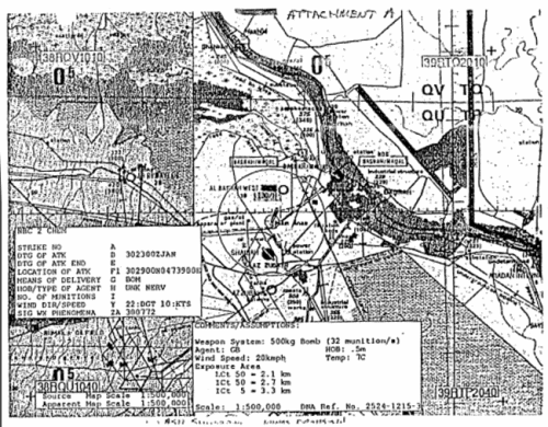
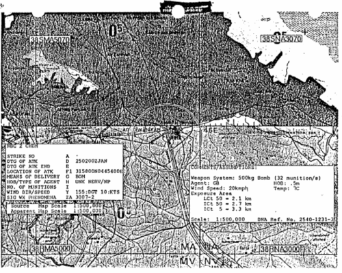
Re: United States Dual-Use Exports to Iraq and Their Impact
![]() by admin » Thu Dec 17, 2015 7:15 pm
by admin » Thu Dec 17, 2015 7:15 pm
An Improved Chemical and Biological Downwind Hazard Prediction System
by Colonel Joseph P. Phillip, USA Lieutenant Colonel Ben E. Moberley, USA Captain David L. De Vries, USA
Defense Nuclear Agency
17 July 1991
ABSTRACT
It is essential that combat commanders have clear, timely, and definitive information and advice on the potential effects of chemical and biological (CB) weapons for decisions affecting troop safety and operational mobility. However, current prediction methods generate broad outlines of total expected areas of potential hazards. Even where automated and enhanced, because of necessary allowances for statistical variability of weather, these methods show hazard areas encompassing even larger portions of terrain without any better appreciation for the significance of the true hazard. Capitalizing on expertise in nuclear effects modeling, the Defense Nuclear Agency in January 1991 rapidly conducted work to provide an improved CB downwind hazard prediction system for Operation Desert Storm. The project was undertaken in direct response to concerns over the CB warfare threat in the Persian Gulf conflict. The system, called ANBACIS II for beneficial association with the Army's Automated Nuclear, Biological And Chemical Information System, provides for greater definition of potential hazard areas by drawing map overlay contours of different dosage intensity according to specific, detailed weapons intelligence information. ANBACIS II packages detailed weapons effects models together with real-time weather input and digital raster maps; all within a user friendly, interactive graphical interface. The result is dramatic visualization capability coupled with substantial computer power. The benefit to the combat commander is a more discrete prediction of the probable extent of serious contamination from cloud travel, greatly enhancing the understanding of impact on mission accomplishment. (See Output Comparison, Figure 1). The concept for the ANBACIS II system was developed and coordinated in November and December, 1990. Work effectively started the first of January, 1991and was completed within 45 days. The system became fully operational on 30 January and served the United States Central Command (CENTCOM) throughout Desert Storm. As finally configured, strike and exercise reports from field commands were telephoned into the Defense Nuclear Agency's Operations Canter. There, system operators used the interactive ANBACIS II system to access a pre-computed database of over 11,000 contour "footprints" for various weapons, agents, and weather conditions. The system and its operators were challenged by over 600 test exercise and strike message requests called into the Continental United States (CONUS) operations canter from U.S. forces elements within the Kuwaiti Theater of Operations. Responses were provided within 10 minutes by facsimile transmission over secure telephone lines. The replies, in the form of map contour overlays of different chemical and biological dosage limits of significance, allowed for scenario analysis and better advice to commanders. ANBACIS II shows great promise as a modular improvement to automated NBC warning and reporting systems. Additionally, the graphical interface proves that common handling and display of various effects base models is possible, not only in warfare but also in evaporation models for accidents and spills. Rapid development and improvement in weather and terrain accommodation are also possible, to include three dimensional resolution. The software is readily adaptable to common user type equipment and small, notebook-size commercial personal computer platforms. In synergy with detection capability, ANBACIS II is a significant advance in contamination avoidance capability, thereby promoting success on the contaminated battlefield.
1. INTRODUCTION
1.1 Purpose
The Automated Nuclear, Biological and Chemical Information System II (ANBACIS II) was developed to provide a more realistic, real-time chemical and biological (CB) downwind hazard prediction capability for United States and coalition forces to evaluate potential hazards to forces and availability of terrain for maneuver. The effort focused on improving the existing Allied Technical Publication No. 45 (ATP-45) system which provides a very large, safe-sided hazard area estimate containing more than 99% of chemical and/or biological agents. The final user products are prediction contour plots that are of tactical significance. (See Output Comparison, figure 1)
1.2 Current Service Capabilities
Throughout the services, there is limited capability for CB hazard prediction. The doctrinal standard, Vol II, ATF-45, allows for changing wind directions, but this only takes a larger, more conservative fan. It also is not an automated process. The Air force continues to rely on existing manual method of ATP-45.
The Army ANBACIS I system automates AT7-45 on DOD personal computers. It provides significantly faster computations, but still gives a large fan and has limited biological capability. The Chemical Research, Development and Engineering Center (CRDEC) developed the basic defensive research weapons models (called NUSSE-4 and PARACOMPT) which have been incorporated into ANBACIS II.
The U.S. Marines acquired a handheld ZENBC system recently developed by the United Kingdom. It also automates ATT-45 and is ruggedized and portable but provides less capability than ANBACIS I. It has no biological hazard prediction capability.
The U.S. Navy developed VLSTRACK for chemical hazard prediction. It has a similar capability as the basic weapons models incorporated into ANBACIS II but is able to use varying winds. It was not fully developed nor evaluated before Desert Storm. The Naval Surface Warfare Center (NSWC) developed a biological "Plume" model which provides more intuitive, realistic looking plots using varying weather conditions. Plume is now incorporated into ANBACIS II.
2. BACKGROUND
2.1 Concept Initiation
During the buildup of Operation Desert Shield, there was great concern over the CB warfare threat in the Persian Gulf. In November 1990, the Director of DNA, Major General Gerald C. Watson, viewed a computer visualization demonstration of a three dimensional transport and diffusion model incorporating local wind and terrain data. Prom this, he conceived the idea of including such a model in the Army ANBACIS program which was already deployed to Army commands in Saudi Arabia. He than formed a team of chemical experts to review and survey existing models that could be used to develop an improved CB hazard prediction visualization product for CENTCOM commanders.
2.2 Model Evaluation
At the time, there were no operational models available which incorporated both weather and terrain data. Several research and development models were reviewed for feasibility and operational use. The team evaluated a model by the U.S. Army Atmospheric Sciences Laboratories (ASL) which incorporated weather and terrain inputs but was not sufficiently developed for immediate operational use. The United States Army Nuclear and Chemical Agency (USANCA) funded Los Alamos National Laboratory (LANL) model - HOTMAC/RAPTAD - was also reviewed but it was not able to handle bursting munition data. Therefore, the team initially settled on using NUSSE-4/PARACOMPT for chemical prediction and GAPCAP/VAMTECAP for biological. These models, developed by CRDEC for single and multiple munitions scenarios respectively, contain essential munitions data but only basic single vector winds for weather input.
2.3 Justification for DNA Lead
DNA's past work on nuclear, dust and smoke transport modeling provided the necessary technical and experience base to develop and integrate such an ambitious project. DNA also supported the Army's development of the ANBACIS I program which automated the safe-sided prediction of ATP-45. Because of its mission, DNA also had a core of chemical officers already assigned who became the nucleus of the modeling and validation.
2.4 Coordination
Coordination in initiating the project and to keep it on track was constant and very thorough. Technical experts from within DNA initially visited the U.S. Army Chemical School, Ft McClellan. AL and ASL at White Sands Missile Range, NM. As the initial concept came to life, several discussions pertaining to modeling, and its various factors, were discussed with ASL, LANL and CRDEC. The operational concept was coordinated with Offices of the Secretary of Defense (OSD), Joint Staff, Department of the Army Deputy Chief of Staff for Operations (DCSOPS), the Defense and Central Intelligence Agencies, CRDEC, the U.S. Army Chemical School, and CENTCOM.
2.5 Schedule
From the onset and throughout the active project, a schedule was developed and continually modified according to the circumstances. As work transpired, the actual accomplishments were:
3. ACTIONS PRECEDING CONFLICT (Desert Shield)
3.1 Project Team
As the various input models were being gathered and assimilated, Applied Computing Systems, Inc. was contracted to Integrate the models into an operational system and provide for an enhanced visual output. Selected personnel from other government and contractor organizations (Air force Systems Command, LANL, CRDEC, SAIC, MITRE, JAYCOR) were also brought in to further develop, evaluate, and operate the working models. A representative from Air Force Global Weather Center (AFGWC) also joined the project and assisted in establishing on-line weather support and an operational weather analysis cell. He installed the Automated Weather Network (AWN) in the DNA Operations Center which provided the hourly surface weather observations used to continually update weather forecasts for the Kuwaiti Theater of Operations. The AFGWC also provided three military weather forecasters which gave a round- the-clock weather analysis capability.
3.2 Model Selection
The CRDEC-developed NUSSE-4 and PARACOMPT models were selected for chemical predictions and the GAPCAP and VAMTECAP models were initially used for biological predictions. A limitation of these models was that they only accepted single vector winds in their calculations. This was not considered a serious deficiency for the chemical predictions since the significant level of contamination from hazardous clouds usually lasted only 1 to 3 hours and traveled only a relatively few tens of kilometers downwind. The large numbers of fielded chemical detectors able to alarm on actual contamination offset micro-climate capabilities. Biological agents, however, could drift downwind 8 to 12 hours and possibly extend several hundred kilometers while still remaining virulent. For this reason, the NSWC biological Plume model, which accounted for varying meteorological conditions (wind speed, direction, and stability category) and varying biological decay rates (in the night/day transition), was finally selected to be the primary biological prediction model.
The NUSSE-4 and Plume models were written in a combination of FORTRAN and C programming language, for use in a Unix operating environment. These models did not have user friendly input interfaces nor operating routines. Consequently, operators made numerous errors and spent much time entering data and calculating responses to message reports because lengthy path and file names were required. To correct this, ACS developed a user friendly, menu driven interface so anyone with minimal training could perform special chemical or biological calculations. This interface proved invaluable and allowed for continued use of these models by non-modeling or computer experts.
3.3 Operation and Methodology
The Sun SPARC 2 workstation was the primary operational platform used to do the hazard predictions. As fast as this computer is, it still often took 15- 20 minutes to perform some calculations and was not sufficient to meet the operational turn around time goal of 10 minutes (from receipt of a strike report from the field to faxing back a contour prediction plot). This prompted a decision to create a database of pre-computed chemical footprints based on suspected Iraqi munitions and agents and various preselected meteorological conditions. The ANBACIS II system has the capability to interact directly with supporting technical models for special computations, or to access a precomputed chemical database in normal use. (See the System Design, Figure 2) To help create the database rapidly, modelers and operators ran the various prediction problems remotely on the DNA Cray computer located at LANL. In the end, more than 11,000 pre-computed footprints were established for the database. At one tine, four Cray computers were linked together to perform spray system calculations quickly. While the Crays were necessary, the reason was solely to accomplish a large volume of calculations in a short time. With a less stressful schedule, lesser platforms can adequately perform all necessary calculations. On the workstations, biological footprints remain processed on subordinate windows using interactive screens which drive the model and allow input of forecast and changes in weather data. The Plume model within ANBACIS II runs quickly (only about 5 more minutes for a 15 minute turn around time). Biological requests can be updated with weather changes until actual weather reports signify s completed pattern. (See Examples of Input Screen and Overlay Output, Figure 3)
3.4 Product for the Field
The team also decided that rather than deploy computer equipment to CENTCOM for a centralized in-theater hazard prediction focal point, it would be less burdensome and more efficient to have all the calculations and analyses performed in the United States. To get the necessary information back and forth quickly (strike reports from CENTCOM units and hazard prediction plots returned to CENTCOM), the Director, DNA offered to provide and install classified facsimile machines and STU-III secure telephones. In all, 21 sets of equipment were deployed according to a CENTCOM distribution plan. There were several factors influencing the numbers of systems - overall cost and availability as well as the number of reasonable command nodes requiring assistance, yet able to collate and manage the NBC Warning and Reporting System (NBCWRS).
4. ACTIONS DURING CONFLICT (Desert Storm: Air & Ground Campaign)
4.1 Deployment and System Operation
Shortly after the air war of Desert Storm began, DNA sent four officers to Saudi Arabia with secure facsimile machines and STU-III telephones. The equipment was installed at 15 locations as directed by CENTCOM. By 30 January, all the equipment was in place, many pre-computed footprints were already developed, and the operating crews were trained. The DNA Operations Center became fully operational on a 24 hour basis. Three shifts, each with an operations cell (military personnel from within DNA), a modeling cell, and a weather cell conducted round-the-clock operations.
The modeling cell consisted of computer and chemical experts from LANL, SAIC, MITRE, and JAYCOR. This cell, via a highspeed computer network link to the DNA Cray computer at LANL, created the footprint database and ran special calculations as requested by CENTCOM units. The Central Intelligence Agency (CIA) also used the ANBACIS II products for their own analysis. Once completed, all footprints and other calculation results were stored on a local computer at DNA. This information was then available for all operators to use as an immediate response to a chemical or biological strike or test exercise report.
The weather cell consisted of trained military weather analysts and forecasters from the U.S. Air Force Air Weather Service. Normally, one non- commissioned officer was assigned to a particular shift. He was responsible for validating the significant weather entries on the NBC-2 reports or predicting weather forecasts for special exercise missions.
4.2 Scheme of Operations
The general scheme of operations was:
1) Units would telephone in NBC-2 reports to the Operations Center. The NBC-2 report would be completed IAW standard doctrine; each report would have a unique strike serial number and the local weather data.
2) Concurrent with a weather check, one of the computer operators would input the NBC-2 report data into the Sun workstation and call up the correct pre-computed footprint. He would than scale it to the user requested map scale and print it.
3) The printed hazard prediction, containing remarks blocks with the original NBC-2 report and essential text data supporting the contour plots, was reviewed for accuracy by the Chemical and Shift Officer-in- Charge.
4) Once approved, the Communications Officer dispatched the prediction plot to the originating unit via secure facsimile.
All of this was accomplished within 10 minutes. To allow for receipt of multiple strike reports from different units at the same time, six computer operators were always available to conduct simultaneous, multi-tasking calculations from any of the six networked workstations if necessary.
4.3 System Usage
When Desert Storm first began, a series of bunker problems were calculated to estimate the effects of coalition bombing of suspected CB production and storage facilities in Iraq. Weapons storage quantities were based on estimates provided by personnel from the United States Army Armament Munitions and Chemical Command (AMCCOM) . The resultant downwind hazard prediction plots were provided to Joint and Service staffs and to the National Military Command Center (NMCC) to assist in overall battle damage assessment. Special calculations were conducted at the request of several agencies. These included assessing potential hazards resulting from intercepts of Scud missiles and the extent of effects of possible chemical or biological attacks on population centers.
An important part of the ANBACIS II system was the integration of Defense Mapping Agency (DMA) ARC Digitized Raster Graphics (ADRG) maps on compact disc read-only-memory (CD-ROM) optical disks. DMA provided CD-ROM maps in scales of 1:250,000, 1:500, 000, 1:1,000,000, and 1:2,000, 000 for each area of interest in a most timely manner. Since CD-ROM maps were not available in 1:50,000 scale, DMA provided paper maps for those areas surrounding the major CENTCOM air bases of interests. These were then digitally scanned at DNA, logically linked together and added to the map database on the system server. All hazard prediction plots could then be printed (in black and white or in color) with a map background if requested. Usually, the map background was not provided because of the additional time in printing the complete map and plot, and in transmitting that detail of information over a 2400 bits per second, analog voice circuit with the facsimile. Map backgrounds were routinely provided in CONUS when the plots were to be presented during command and staff briefings. Overlay plots were routinely sent for CENTCOM for posting on operations maps.
4.4 Coordination and Briefings
Continuous coordination was made with the Army Chemical School, CRDEC, Surgeon General's Office (for agent toxicological data), and numerous intelligence agencies to refine the weapons and chemical/biological agent database to ensure that the footprints produced would be according to the best, most accurate data available. At one point, when new and additional weapons and fuzing information was received, an entirely new footprint database was generated and each entry was individually validated.
Throughout the operation, numerous briefings and demonstrations were given to high level officials to acquaint them with this new, significant contribution to the war effort and need for continued work.
While there were no actual chemical or biological strikes during the war, continuous exercise strikes were generated to ensure that CENTCOM units and DNA operations personnel remained proficient. In all, more than 600 plots were calculated and dispatched to units in Saudi Arabia. The Army Division and Corps NBC staffs requested numerous specific plots so they could perform vulnerability analysis to visually show commanders the results of potential enemy CB attacks. These plots were used in daily briefings as Commanders planned their defensive and offensive operations. A tabular summary is included in figure 4.
5. ACTIONS AFTER CONFLICT
Since the cessation of conflict, the majority of the effort has centered on cleaning up the software code, writing the documentation, and developing a transition plan to ensure that this landmark contribution is properly carried forth for continued development by the Services.
Several briefings and demonstrations have also been conducted to create a greater understanding and awareness of the enhance and improved hazard prediction capabilities that are possible now. As a result of demonstrating the system at the various conferences, there has been a great demand for a DOS version of a database of pre-computed footprints. This capability has been developed using a notebook size PC. An effort is underway to demonstrate a full system capability on either a common user or other commercial platforms. ANBACIS II fulfilled an immediate requirement for an improved prediction capability, better training tools, improved advice to commanders and system adaptability to smaller computers. Figure 5 details future system enhancements and goals.
6. LESSONS LEARNED
Improved prediction capabilities are available now with existing technology; more is needed to make the system faster, more accurate, and more user friendly.
As models are enhanced to allow for changing meteorological conditions, timely and accurate weather information becomes critical. Automatic infusion of weather data, such as from the Army's Integrated Meteorological System (IMETS), is needed to drive the models. Combinations of weather sensors and reporting stations proliferated throughout the area of operation, or by satellite with lookdown capability for micro-meteorological conditions, will provide real-time data feed for systems such as ANBACIS II.
Sufficient intelligence data must be made more available. A common, standardized database of threat weapons, agents, fill weights and other weapon parameters, as well as weather parametric data, is required to establish footprints for various regional threat scenarios.
Commercial communications systems proved adequate and practical for this particular situation for training and wargaming. Large scale use of CB would have overloaded the ability to report or respond immediately. There is an urgent need either to construct data distribution systems that span both strategic and tactical communications networks and is capable of transmitting large amounts of data (images, files or packets), or to downsize and distribute a direct ANBACIS II system capability within units.
There has been no centralized DoD level focus on model development or NBC battlefield automation techniques. Each service has established their own separate methods of performing hazard calculations and transmitting NBC reports. In a Joint Task Force Operation, such as Operation Desert Storm and as will always be in future conflicts, all should be operating from a standardized system. A DoD level agency should be designated to ensure a standardized capability is established.
7. RECOMMENDATIONS
The ANBACIS II effort proved the utility of a common, user friendly Interface for many purposes. Development should continue with system transition as a joint Service project. Specifically, development should:
1. provide for a DOD level focus for NBC battlefield automation.
2. establish a DoD standardized NBC hazard prediction model interface incorporating automated real-time weather and digital terrain data on common user equipment.
3. add a nuclear fallout and smoke assessment system and accident/incident/environmental modules to make improved downwind hazard prediction systems for all nuclear, biological, chemical, and other hazardous materials situations. [HANDWRITTEN: FAS HOTMAC/RAPTAD]
4. incorporate ANBACIS II into the U.S. ANBACIS and NATO ATP-45 as an improvement to the current NBC-3 report.
5. downsize and proliferate ANBACIS II software to operate on common user platforms.
6. assign development and operations centers to build and use general and theater specific databases of footprints.
7. create unclassified databases for use in classroom training and field exercise situations.
8. maintain a network for exchange of data and to conduct regular test exercises, among all elements.
by Colonel Joseph P. Phillip, USA Lieutenant Colonel Ben E. Moberley, USA Captain David L. De Vries, USA
Defense Nuclear Agency
17 July 1991
ABSTRACT
It is essential that combat commanders have clear, timely, and definitive information and advice on the potential effects of chemical and biological (CB) weapons for decisions affecting troop safety and operational mobility. However, current prediction methods generate broad outlines of total expected areas of potential hazards. Even where automated and enhanced, because of necessary allowances for statistical variability of weather, these methods show hazard areas encompassing even larger portions of terrain without any better appreciation for the significance of the true hazard. Capitalizing on expertise in nuclear effects modeling, the Defense Nuclear Agency in January 1991 rapidly conducted work to provide an improved CB downwind hazard prediction system for Operation Desert Storm. The project was undertaken in direct response to concerns over the CB warfare threat in the Persian Gulf conflict. The system, called ANBACIS II for beneficial association with the Army's Automated Nuclear, Biological And Chemical Information System, provides for greater definition of potential hazard areas by drawing map overlay contours of different dosage intensity according to specific, detailed weapons intelligence information. ANBACIS II packages detailed weapons effects models together with real-time weather input and digital raster maps; all within a user friendly, interactive graphical interface. The result is dramatic visualization capability coupled with substantial computer power. The benefit to the combat commander is a more discrete prediction of the probable extent of serious contamination from cloud travel, greatly enhancing the understanding of impact on mission accomplishment. (See Output Comparison, Figure 1). The concept for the ANBACIS II system was developed and coordinated in November and December, 1990. Work effectively started the first of January, 1991and was completed within 45 days. The system became fully operational on 30 January and served the United States Central Command (CENTCOM) throughout Desert Storm. As finally configured, strike and exercise reports from field commands were telephoned into the Defense Nuclear Agency's Operations Canter. There, system operators used the interactive ANBACIS II system to access a pre-computed database of over 11,000 contour "footprints" for various weapons, agents, and weather conditions. The system and its operators were challenged by over 600 test exercise and strike message requests called into the Continental United States (CONUS) operations canter from U.S. forces elements within the Kuwaiti Theater of Operations. Responses were provided within 10 minutes by facsimile transmission over secure telephone lines. The replies, in the form of map contour overlays of different chemical and biological dosage limits of significance, allowed for scenario analysis and better advice to commanders. ANBACIS II shows great promise as a modular improvement to automated NBC warning and reporting systems. Additionally, the graphical interface proves that common handling and display of various effects base models is possible, not only in warfare but also in evaporation models for accidents and spills. Rapid development and improvement in weather and terrain accommodation are also possible, to include three dimensional resolution. The software is readily adaptable to common user type equipment and small, notebook-size commercial personal computer platforms. In synergy with detection capability, ANBACIS II is a significant advance in contamination avoidance capability, thereby promoting success on the contaminated battlefield.
1. INTRODUCTION
1.1 Purpose
The Automated Nuclear, Biological and Chemical Information System II (ANBACIS II) was developed to provide a more realistic, real-time chemical and biological (CB) downwind hazard prediction capability for United States and coalition forces to evaluate potential hazards to forces and availability of terrain for maneuver. The effort focused on improving the existing Allied Technical Publication No. 45 (ATP-45) system which provides a very large, safe-sided hazard area estimate containing more than 99% of chemical and/or biological agents. The final user products are prediction contour plots that are of tactical significance. (See Output Comparison, figure 1)
1.2 Current Service Capabilities
Throughout the services, there is limited capability for CB hazard prediction. The doctrinal standard, Vol II, ATF-45, allows for changing wind directions, but this only takes a larger, more conservative fan. It also is not an automated process. The Air force continues to rely on existing manual method of ATP-45.
The Army ANBACIS I system automates AT7-45 on DOD personal computers. It provides significantly faster computations, but still gives a large fan and has limited biological capability. The Chemical Research, Development and Engineering Center (CRDEC) developed the basic defensive research weapons models (called NUSSE-4 and PARACOMPT) which have been incorporated into ANBACIS II.
The U.S. Marines acquired a handheld ZENBC system recently developed by the United Kingdom. It also automates ATT-45 and is ruggedized and portable but provides less capability than ANBACIS I. It has no biological hazard prediction capability.
The U.S. Navy developed VLSTRACK for chemical hazard prediction. It has a similar capability as the basic weapons models incorporated into ANBACIS II but is able to use varying winds. It was not fully developed nor evaluated before Desert Storm. The Naval Surface Warfare Center (NSWC) developed a biological "Plume" model which provides more intuitive, realistic looking plots using varying weather conditions. Plume is now incorporated into ANBACIS II.
2. BACKGROUND
2.1 Concept Initiation
During the buildup of Operation Desert Shield, there was great concern over the CB warfare threat in the Persian Gulf. In November 1990, the Director of DNA, Major General Gerald C. Watson, viewed a computer visualization demonstration of a three dimensional transport and diffusion model incorporating local wind and terrain data. Prom this, he conceived the idea of including such a model in the Army ANBACIS program which was already deployed to Army commands in Saudi Arabia. He than formed a team of chemical experts to review and survey existing models that could be used to develop an improved CB hazard prediction visualization product for CENTCOM commanders.
2.2 Model Evaluation
At the time, there were no operational models available which incorporated both weather and terrain data. Several research and development models were reviewed for feasibility and operational use. The team evaluated a model by the U.S. Army Atmospheric Sciences Laboratories (ASL) which incorporated weather and terrain inputs but was not sufficiently developed for immediate operational use. The United States Army Nuclear and Chemical Agency (USANCA) funded Los Alamos National Laboratory (LANL) model - HOTMAC/RAPTAD - was also reviewed but it was not able to handle bursting munition data. Therefore, the team initially settled on using NUSSE-4/PARACOMPT for chemical prediction and GAPCAP/VAMTECAP for biological. These models, developed by CRDEC for single and multiple munitions scenarios respectively, contain essential munitions data but only basic single vector winds for weather input.
2.3 Justification for DNA Lead
DNA's past work on nuclear, dust and smoke transport modeling provided the necessary technical and experience base to develop and integrate such an ambitious project. DNA also supported the Army's development of the ANBACIS I program which automated the safe-sided prediction of ATP-45. Because of its mission, DNA also had a core of chemical officers already assigned who became the nucleus of the modeling and validation.
2.4 Coordination
Coordination in initiating the project and to keep it on track was constant and very thorough. Technical experts from within DNA initially visited the U.S. Army Chemical School, Ft McClellan. AL and ASL at White Sands Missile Range, NM. As the initial concept came to life, several discussions pertaining to modeling, and its various factors, were discussed with ASL, LANL and CRDEC. The operational concept was coordinated with Offices of the Secretary of Defense (OSD), Joint Staff, Department of the Army Deputy Chief of Staff for Operations (DCSOPS), the Defense and Central Intelligence Agencies, CRDEC, the U.S. Army Chemical School, and CENTCOM.
2.5 Schedule
From the onset and throughout the active project, a schedule was developed and continually modified according to the circumstances. As work transpired, the actual accomplishments were:
Item / Date
Initiated Project / 1 November 1990
Concept Briefings / November 1990 - January 1991
Support Contract Awarded / 24 December 1990
Concept Message (J-3 CENTCOM) / 28 December 1990
System Functional / 11 January 1991
Install Equipment in Theater / 22 - 30 January 1991
System Operational / 30 January 1991
24 Hour Operations Stopped / 4 March 1991
Operations Terminated / 11 March 1991
3. ACTIONS PRECEDING CONFLICT (Desert Shield)
3.1 Project Team
As the various input models were being gathered and assimilated, Applied Computing Systems, Inc. was contracted to Integrate the models into an operational system and provide for an enhanced visual output. Selected personnel from other government and contractor organizations (Air force Systems Command, LANL, CRDEC, SAIC, MITRE, JAYCOR) were also brought in to further develop, evaluate, and operate the working models. A representative from Air Force Global Weather Center (AFGWC) also joined the project and assisted in establishing on-line weather support and an operational weather analysis cell. He installed the Automated Weather Network (AWN) in the DNA Operations Center which provided the hourly surface weather observations used to continually update weather forecasts for the Kuwaiti Theater of Operations. The AFGWC also provided three military weather forecasters which gave a round- the-clock weather analysis capability.
3.2 Model Selection
The CRDEC-developed NUSSE-4 and PARACOMPT models were selected for chemical predictions and the GAPCAP and VAMTECAP models were initially used for biological predictions. A limitation of these models was that they only accepted single vector winds in their calculations. This was not considered a serious deficiency for the chemical predictions since the significant level of contamination from hazardous clouds usually lasted only 1 to 3 hours and traveled only a relatively few tens of kilometers downwind. The large numbers of fielded chemical detectors able to alarm on actual contamination offset micro-climate capabilities. Biological agents, however, could drift downwind 8 to 12 hours and possibly extend several hundred kilometers while still remaining virulent. For this reason, the NSWC biological Plume model, which accounted for varying meteorological conditions (wind speed, direction, and stability category) and varying biological decay rates (in the night/day transition), was finally selected to be the primary biological prediction model.
The NUSSE-4 and Plume models were written in a combination of FORTRAN and C programming language, for use in a Unix operating environment. These models did not have user friendly input interfaces nor operating routines. Consequently, operators made numerous errors and spent much time entering data and calculating responses to message reports because lengthy path and file names were required. To correct this, ACS developed a user friendly, menu driven interface so anyone with minimal training could perform special chemical or biological calculations. This interface proved invaluable and allowed for continued use of these models by non-modeling or computer experts.
3.3 Operation and Methodology
The Sun SPARC 2 workstation was the primary operational platform used to do the hazard predictions. As fast as this computer is, it still often took 15- 20 minutes to perform some calculations and was not sufficient to meet the operational turn around time goal of 10 minutes (from receipt of a strike report from the field to faxing back a contour prediction plot). This prompted a decision to create a database of pre-computed chemical footprints based on suspected Iraqi munitions and agents and various preselected meteorological conditions. The ANBACIS II system has the capability to interact directly with supporting technical models for special computations, or to access a precomputed chemical database in normal use. (See the System Design, Figure 2) To help create the database rapidly, modelers and operators ran the various prediction problems remotely on the DNA Cray computer located at LANL. In the end, more than 11,000 pre-computed footprints were established for the database. At one tine, four Cray computers were linked together to perform spray system calculations quickly. While the Crays were necessary, the reason was solely to accomplish a large volume of calculations in a short time. With a less stressful schedule, lesser platforms can adequately perform all necessary calculations. On the workstations, biological footprints remain processed on subordinate windows using interactive screens which drive the model and allow input of forecast and changes in weather data. The Plume model within ANBACIS II runs quickly (only about 5 more minutes for a 15 minute turn around time). Biological requests can be updated with weather changes until actual weather reports signify s completed pattern. (See Examples of Input Screen and Overlay Output, Figure 3)
3.4 Product for the Field
The team also decided that rather than deploy computer equipment to CENTCOM for a centralized in-theater hazard prediction focal point, it would be less burdensome and more efficient to have all the calculations and analyses performed in the United States. To get the necessary information back and forth quickly (strike reports from CENTCOM units and hazard prediction plots returned to CENTCOM), the Director, DNA offered to provide and install classified facsimile machines and STU-III secure telephones. In all, 21 sets of equipment were deployed according to a CENTCOM distribution plan. There were several factors influencing the numbers of systems - overall cost and availability as well as the number of reasonable command nodes requiring assistance, yet able to collate and manage the NBC Warning and Reporting System (NBCWRS).
4. ACTIONS DURING CONFLICT (Desert Storm: Air & Ground Campaign)
4.1 Deployment and System Operation
Shortly after the air war of Desert Storm began, DNA sent four officers to Saudi Arabia with secure facsimile machines and STU-III telephones. The equipment was installed at 15 locations as directed by CENTCOM. By 30 January, all the equipment was in place, many pre-computed footprints were already developed, and the operating crews were trained. The DNA Operations Center became fully operational on a 24 hour basis. Three shifts, each with an operations cell (military personnel from within DNA), a modeling cell, and a weather cell conducted round-the-clock operations.
The modeling cell consisted of computer and chemical experts from LANL, SAIC, MITRE, and JAYCOR. This cell, via a highspeed computer network link to the DNA Cray computer at LANL, created the footprint database and ran special calculations as requested by CENTCOM units. The Central Intelligence Agency (CIA) also used the ANBACIS II products for their own analysis. Once completed, all footprints and other calculation results were stored on a local computer at DNA. This information was then available for all operators to use as an immediate response to a chemical or biological strike or test exercise report.
The weather cell consisted of trained military weather analysts and forecasters from the U.S. Air Force Air Weather Service. Normally, one non- commissioned officer was assigned to a particular shift. He was responsible for validating the significant weather entries on the NBC-2 reports or predicting weather forecasts for special exercise missions.
4.2 Scheme of Operations
The general scheme of operations was:
1) Units would telephone in NBC-2 reports to the Operations Center. The NBC-2 report would be completed IAW standard doctrine; each report would have a unique strike serial number and the local weather data.
2) Concurrent with a weather check, one of the computer operators would input the NBC-2 report data into the Sun workstation and call up the correct pre-computed footprint. He would than scale it to the user requested map scale and print it.
3) The printed hazard prediction, containing remarks blocks with the original NBC-2 report and essential text data supporting the contour plots, was reviewed for accuracy by the Chemical and Shift Officer-in- Charge.
4) Once approved, the Communications Officer dispatched the prediction plot to the originating unit via secure facsimile.
All of this was accomplished within 10 minutes. To allow for receipt of multiple strike reports from different units at the same time, six computer operators were always available to conduct simultaneous, multi-tasking calculations from any of the six networked workstations if necessary.
4.3 System Usage
When Desert Storm first began, a series of bunker problems were calculated to estimate the effects of coalition bombing of suspected CB production and storage facilities in Iraq. Weapons storage quantities were based on estimates provided by personnel from the United States Army Armament Munitions and Chemical Command (AMCCOM) . The resultant downwind hazard prediction plots were provided to Joint and Service staffs and to the National Military Command Center (NMCC) to assist in overall battle damage assessment. Special calculations were conducted at the request of several agencies. These included assessing potential hazards resulting from intercepts of Scud missiles and the extent of effects of possible chemical or biological attacks on population centers.
An important part of the ANBACIS II system was the integration of Defense Mapping Agency (DMA) ARC Digitized Raster Graphics (ADRG) maps on compact disc read-only-memory (CD-ROM) optical disks. DMA provided CD-ROM maps in scales of 1:250,000, 1:500, 000, 1:1,000,000, and 1:2,000, 000 for each area of interest in a most timely manner. Since CD-ROM maps were not available in 1:50,000 scale, DMA provided paper maps for those areas surrounding the major CENTCOM air bases of interests. These were then digitally scanned at DNA, logically linked together and added to the map database on the system server. All hazard prediction plots could then be printed (in black and white or in color) with a map background if requested. Usually, the map background was not provided because of the additional time in printing the complete map and plot, and in transmitting that detail of information over a 2400 bits per second, analog voice circuit with the facsimile. Map backgrounds were routinely provided in CONUS when the plots were to be presented during command and staff briefings. Overlay plots were routinely sent for CENTCOM for posting on operations maps.
4.4 Coordination and Briefings
Continuous coordination was made with the Army Chemical School, CRDEC, Surgeon General's Office (for agent toxicological data), and numerous intelligence agencies to refine the weapons and chemical/biological agent database to ensure that the footprints produced would be according to the best, most accurate data available. At one point, when new and additional weapons and fuzing information was received, an entirely new footprint database was generated and each entry was individually validated.
Throughout the operation, numerous briefings and demonstrations were given to high level officials to acquaint them with this new, significant contribution to the war effort and need for continued work.
While there were no actual chemical or biological strikes during the war, continuous exercise strikes were generated to ensure that CENTCOM units and DNA operations personnel remained proficient. In all, more than 600 plots were calculated and dispatched to units in Saudi Arabia. The Army Division and Corps NBC staffs requested numerous specific plots so they could perform vulnerability analysis to visually show commanders the results of potential enemy CB attacks. These plots were used in daily briefings as Commanders planned their defensive and offensive operations. A tabular summary is included in figure 4.
5. ACTIONS AFTER CONFLICT
Since the cessation of conflict, the majority of the effort has centered on cleaning up the software code, writing the documentation, and developing a transition plan to ensure that this landmark contribution is properly carried forth for continued development by the Services.
Several briefings and demonstrations have also been conducted to create a greater understanding and awareness of the enhance and improved hazard prediction capabilities that are possible now. As a result of demonstrating the system at the various conferences, there has been a great demand for a DOS version of a database of pre-computed footprints. This capability has been developed using a notebook size PC. An effort is underway to demonstrate a full system capability on either a common user or other commercial platforms. ANBACIS II fulfilled an immediate requirement for an improved prediction capability, better training tools, improved advice to commanders and system adaptability to smaller computers. Figure 5 details future system enhancements and goals.
6. LESSONS LEARNED
Improved prediction capabilities are available now with existing technology; more is needed to make the system faster, more accurate, and more user friendly.
As models are enhanced to allow for changing meteorological conditions, timely and accurate weather information becomes critical. Automatic infusion of weather data, such as from the Army's Integrated Meteorological System (IMETS), is needed to drive the models. Combinations of weather sensors and reporting stations proliferated throughout the area of operation, or by satellite with lookdown capability for micro-meteorological conditions, will provide real-time data feed for systems such as ANBACIS II.
Sufficient intelligence data must be made more available. A common, standardized database of threat weapons, agents, fill weights and other weapon parameters, as well as weather parametric data, is required to establish footprints for various regional threat scenarios.
Commercial communications systems proved adequate and practical for this particular situation for training and wargaming. Large scale use of CB would have overloaded the ability to report or respond immediately. There is an urgent need either to construct data distribution systems that span both strategic and tactical communications networks and is capable of transmitting large amounts of data (images, files or packets), or to downsize and distribute a direct ANBACIS II system capability within units.
There has been no centralized DoD level focus on model development or NBC battlefield automation techniques. Each service has established their own separate methods of performing hazard calculations and transmitting NBC reports. In a Joint Task Force Operation, such as Operation Desert Storm and as will always be in future conflicts, all should be operating from a standardized system. A DoD level agency should be designated to ensure a standardized capability is established.
7. RECOMMENDATIONS
The ANBACIS II effort proved the utility of a common, user friendly Interface for many purposes. Development should continue with system transition as a joint Service project. Specifically, development should:
1. provide for a DOD level focus for NBC battlefield automation.
2. establish a DoD standardized NBC hazard prediction model interface incorporating automated real-time weather and digital terrain data on common user equipment.
3. add a nuclear fallout and smoke assessment system and accident/incident/environmental modules to make improved downwind hazard prediction systems for all nuclear, biological, chemical, and other hazardous materials situations. [HANDWRITTEN: FAS HOTMAC/RAPTAD]
4. incorporate ANBACIS II into the U.S. ANBACIS and NATO ATP-45 as an improvement to the current NBC-3 report.
5. downsize and proliferate ANBACIS II software to operate on common user platforms.
6. assign development and operations centers to build and use general and theater specific databases of footprints.
7. create unclassified databases for use in classroom training and field exercise situations.
8. maintain a network for exchange of data and to conduct regular test exercises, among all elements.
- admin
- Site Admin
- Posts: 36184
- Joined: Thu Aug 01, 2013 5:21 am
Re: United States Dual-Use Exports to Iraq and Their Impact
![]() by admin » Thu Dec 17, 2015 8:38 pm
by admin » Thu Dec 17, 2015 8:38 pm
TABLE 2-1. PREVENTIVE MAINTENANCE CHECKS AND SERVICES
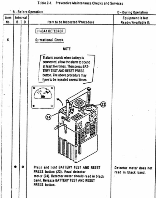
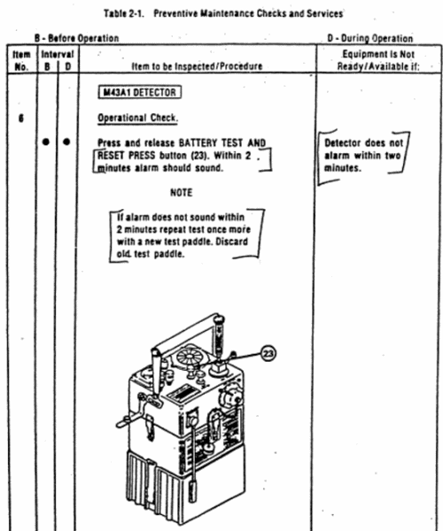
2-10. OPERATING PROCEDURES
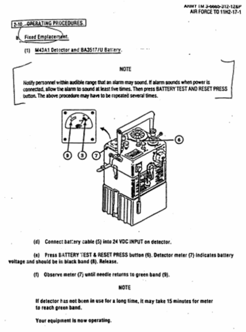
2-16 OPERATION IN BLOWING SAND OR DUST
2-10. OPERATING PROCEDURES
2-16 OPERATION IN BLOWING SAND OR DUST
- admin
- Site Admin
- Posts: 36184
- Joined: Thu Aug 01, 2013 5:21 am
Re: United States Dual-Use Exports to Iraq and Their Impact
![]() by admin » Thu Dec 17, 2015 8:40 pm
by admin » Thu Dec 17, 2015 8:40 pm
ATTACHMENT C: DEFENSE MEDICAL STANDARDIZATION BOARD
'87 VS '90
REPORT: DEPMEDS COMPARE BY NSN
DATE: 10 APR. 90
DMSB
BUILDING 1423
FORT DETRICK
FREDERICK, MD. 21701-5013
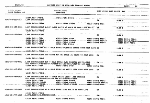
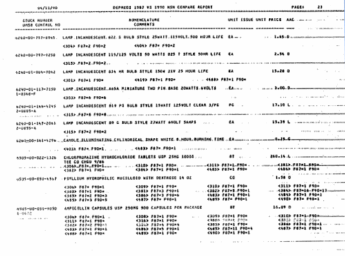

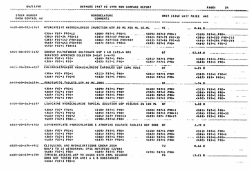
'87 VS '90
REPORT: DEPMEDS COMPARE BY NSN
DATE: 10 APR. 90
DMSB
BUILDING 1423
FORT DETRICK
FREDERICK, MD. 21701-5013
- admin
- Site Admin
- Posts: 36184
- Joined: Thu Aug 01, 2013 5:21 am
Return to Investigations of Government
Who is online
Users browsing this forum: No registered users and 6 guests