CHAPTER 22Denudation of the Valley of the Weald, continued – The alternative of the proposition that the chalk of the North and South Downs were once continuous, considered – Dr. Buckland on the Valley of Kingsclere – Rise and denudation of secondary rocks gradual – Concomitant deposition of tertiary strata gradual – Composition of the latter such as would result from the wreck of the secondary rocks – Valleys and furrows on the chalk how caused – Auvergne, the Paris basin, and south-east of England one region of earthquakes during the Eocene period – Why the central parts of the London and Hampshire basins rise nearly as high as the denudation of the Weald -- Effects of protruding force counteracted by the levelling operations of water – Thickness of masses removed from the central ridge of the Weald – Great escarpment of the chalk having a direction north-east and south-west – Curved and vertical strata in the Isle of Wight – These were convulsed after the deposition of the fresh-water beds of Headen Hill – Elevations of land posterior to the crag – Why no Eocene alluviums recognizable – Concluding remarks on the intermittent operations of earthquakes in the south-east of England, and the gradual formation of valleys – RecapitulationExtent of denudation in the Valley of the Weald. -- 'IT would be highly rash,' observes Mr. Conybeare, speaking of the denudation of the Weald, 'to assume that the chalk at any period actually covered the whole space in which the inferior strata are now exposed, although the truncated form of its escarpment evidently shows it to have once extended much farther than at present.' [1]
We believe that few geologists who have considered the extent of country supposed to have been denuded, and who have explored the hills and valleys of the central, or Forest ridge, without being able to discover the slightest vestige of chalk in the alluvium, [2] will fail to participate, at first, in the doubts here expressed as to the original continuity of the upper secondary formations over the anticlinal axis of the Weald. For our own part, we never traversed the wide space which separates the North and South Downs, without desiring to escape from the conclusions advocated in the last chapter; and yet we have been invariably brought back again to the opinion, that the chalk was originally continuous, on a more deliberate review of the whole phenomena.
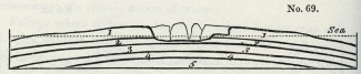
It may be useful to consider the only other alternative of the hypothesis before explained. If the marine groups, Nos. 1, 2, 3, were not originally continuous, it is necessary to imagine that they each terminated at some point between their present outgoings and the secondary strata of the Forest ridge. Thus we might suppose them to have thinned out one after the other, as in the above diagram, and never to have covered the entire area occupied by the fresh-water strata, Nos. 4 and 5.
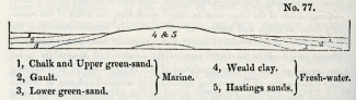 No. 77.
1, Chalk and Upper green-Sand. } Marine.
2, Gault. } Marine.
3, Lower green-sand. } Marine.
4, Weald clay. } Fresh-water.
5, Hastings sands. } Fresh-water.We grant that had such been the original disposition of the different groups, they might, as they gradually emerged from the sea, have become denuded in the manner explained in the last chapter, so that the country might equally have assumed its present configuration. But, although we know of no invincible objection to such an hypothesis, there are certainly no appearances which favour it. If the strata Nos. 4 and 5 had been unconformable to the Lower green-sand No. 3, then, indeed, we might have imagined that the older groups had been disturbed by a series of movements antecedently to the deposition of No. 3, and, in that case, some parts of them might be supposed to have emerged or formed shoals in the ancient sea, interrupting the continuity of the newer marine deposits. But the group No. 4 is conformable to No. 3, and the only change which has been observed to take place at the junction, is an occasional intermixture of the Weald clay with the superior marine sand, such as might have been caused by a slight superficial movement in the waters when the sea first overflowed the fresh-water strata.
On the other hand, the green-sand and chalk, as they approach the central axis of the Weald, are not found to contain littoral shells, or any wreck of the fresh-water strata, such as might indicate the existence of an island with its shores or wasting cliffs. Had any such signs been discovered, we might have been inclined to suppose the geography of the region to have once borne some resemblance to that exhibited in the diagram No. 77.
Dr. Buckland on Valleys of Elevation. -- We are indebted to Dr. Buckland for an able memoir in illustration of several districts of similar form and structure to the Weald, which occur at no great distance in the south of England. His paper is intitled, 'On the formation of the Valley of Kingsclere and other valleys by the elevation of the strata which enclose them.' [3]
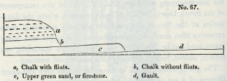
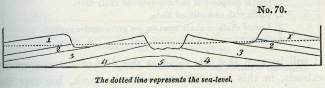
The valley of Kingsclere, situate a few miles south of Newbury, in Berkshire, is about five miles long and two in breadth. The upper and lower chalk, as will be seen in the accompanying section, [4] and the upper green-sand dip in opposite directions from an anticlinal axis which passes through the middle of the valley along the line a, b, of the ground-plan (No. 78).
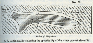 No. 78: Valley of Kingsclere
a,b, Anticlinal line marking the opposite dip of the strata on each side of it.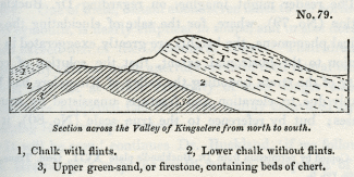 No. 79: Section across the Valley of Kingsclere from north to south.
1, Chalk with flints.
2, Lower chalk without flints.
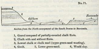
3, Upper green-sand, or firestone, containing beds of chert.We subjoin an additional wood-cut, as conveying a scale of heights more nearly approaching to that of nature, although the altitudes, in proportion to the horizontal extent, are even in this, perhaps, somewhat in excess. On each side of the valley we find escarpments of chalk, the strata of which dip in opposite directions, in the northern escarpment to the north, and in the southern to the south. At the eastern and western extremities of the valley, the two escarpments become confluent, precisely in the same manner as do those of the North and South Downs, at the eastern end of the Weald district, near Petersfield. And as, a few miles east of the town last mentioned (see Map, plate V.), the firestone, or upper green-sand, is laid open in the sharp angle between the escarpment of the Alton Hills and the western termination of the South Downs; [5] so in the valley of Kingsclere the same formation is seen to crop out from beneath the chalk.
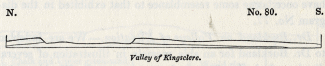 No. 80: Valley of Kingsclere.
The reader might imagine, on regarding Dr. Buckland's section (No. 79), where, for the sake of elucidating the geological phenomena, the heights are greatly exaggerated in proportion to the horizontal extent, that the solution of continuity of the strata bounding the valley of Kingsclere had been simply due to elevation and fracture, unassisted by aqueous causes; but by reference to the true scale (No. 80), it will immediately appear, that a considerable mass of chalk must have been removed by denudation.
If the anticlinal dip had been confined to the valley of Kingsclere, we might have supposed that the upheaving force had acted on a mere point, forcing upwards the superincumbent strata into a small dome-shaped eminence, the crown of which had been subsequently cut off. But Dr. Buckland traced the line of opposite dip far beyond the confluence of the chalk escarpments, and found that it was prolonged in a more northwest direction far beyond the point a, diagram No. 78. In following the line thus extended, the strata are seen in numerous chalk-pits to have an opposite dip on either side of a central axis, from which we may clearly infer the linear direction of the movement. Perhaps the intensity of the disturbing force was greatest where the denudation of the valley of Kingsclere took 'place; but this cannot be confidently inferred, for the quantity of matter removed by aqueous agency must depend on the set of the tides and currents at the period of emergence, and not solely on the amount of elevation and derangement of the strata.
Many of the valleys enumerated by Dr. Buckland as having a similar conformation to that of Kingsclere, run east and west, like the anticlinal ridge of the Weald valley. Several of these occur in Wiltshire and Dorsetshire, and they are all circumscribed by an escarpment whose component strata dip outwards from an anticlinal line running along the central axis of the valley. One of these, distant about seven miles to the north-east of Weymouth, is nearly elliptical in shape, and in size does not much exceed that of the Coliseum at Rome. Their drainage is generally effected by an aperture in one of their lateral escarpments, and not at either extremity of their longer axis, as would have happened had they been simply excavated by the sweeping force of rapid water. [6]
'It will be seen,' continues Dr. Buckland, 'if we follow on Mr. Greenough's map the south-western escarpment of the chalk in the counties of Wilts and Dorset, that, at no great distance from these small elliptical valleys of elevation, there occur several longer and larger valleys, forming deep notches, as it were, in the lofty edge of the chalk. These are of similar structure to the smaller valleys we have been considering, and consist of green-sand, inclosed by chalk at one extremity, and flanked by two escarpments of the same, facing each other with an opposite dip; but they differ in the circumstance of their other and broader extremity being without any such inclosure, and gradually widening till it is lost in the expanse of the adjacent country.
The cases I now allude to are the Vale of Pewsey, to the east of Devizes, that of the Wily, to the east of Warminster, and the valley of the Nadder, extending from Shaftsbury to Barford, near Salisbury; in which last not only the strata of green-sand are brought to the surface, but also the still lower formations of Purbeck and Portland beds, and of Kimmeridge clay.
It might at first sight appear that these valleys are nothing more than simple valleys of denudation; but the fact of the strata composing their escarpments having an opposite and outward dip from the axis of the valley, and this often at a high angle, as near Fonthill and Barford, in the Vale of the Nadder, and at Oare, near the base of Martinsell Hill, in the Vale of Pewsey, obliges us to refer their inclination to some antecedent violence, analogous to that to which I have attributed the position of the strata in the inclosed valleys near Kingsclere, Ham, and Burbage. Nor is it probable that, without some preexisting fracture or opening in the lofty line of the great chalk escarpment, which is here presented to the north-west, the power of water alone would have forced open three such deep valleys as those in question, without causing them to maintain a more equable breadth, instead of narrowing till they end in a point in the body of the chalk. [7]
Rise and denudation of the secondary rocks gradual. -- To return to the valley of the Weald, the strata of the North Downs are inclined to the north, at an angle of from 10° to 15°, and in the narrow ridge of the Hog's back, west of Guildford, in Surrey, about 45°; those in the South Downs dip to the south at a slight angle. It is superfluous to dwell on the analogy which in this respect the two escarpments bear to those which flank the valleys above alluded to; and in regard to the greater distance which separates the hills of Surrey from those of Sussex, the difficulty may be reduced simply to a question of time. If the rise of the land and its degradation by aqueous causes was accomplished by an indefinite number of minor convulsions, during an immense lapse of ages, we behold in the ocean a power fully adequate to perform the work of demolition. If, on the other hand, we embrace the hypothesis of paroxysmal elevation, or, in other words, suppose a submarine tract to have been converted instantaneously into high land, we may seek in vain for any known cause capable of sweeping away even those portions of chalk and other rocks which, all are agreed, must once have formed the prolongation of the existing escarpments. It is common in such cases to call in one arbitrary hypothesis to support another, and as the upheaving force operated with sudden violence, so a vast diluvial wave is introduced to carry away, with almost equal celerity, the mountain mass of strata assumed to have been stripped off.
Materials of the tertiary strata whence derived. -- If, then, we conclude that the wreck of the denuded district was removed gradually, it follows that it was deposited by degrees elsewhere. If any part of the sea immediately adjacent to the district which was then emerging, was of considerable depth, the drift matter would be consigned to that submarine region, since every current charged with sediment must purge itself in the first deep cavity which it traverses, as does a turbid river in a lake. Suppose that while the wave sand currents were excavating the longitudinal valleys, D and C (No. 81, p. 310), the deposits a were thrown down to the bottom of the contiguous deep water E, the sediment being drifted through transverse fissures, as before explained. In this case, the rise of the formations Nos. 1, 2, 3, 4, 5, may have been going on contemporaneously with the excavation of the valleys C and D, and with the accumulation of the strata a. There must be innumerable points on our own coast where the sea is of great depth near to islands and cliffs now exposed to rapid waste, and in all these the denuding and reproductive processes must be going on in the immediate proximity of each other. Such may have been the case during the rise of the Valley of the Weald, and the deposition of the beds of the London and Hampshire basins.
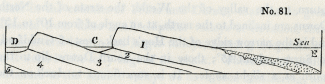 No. 81.
The theory above proposed requires that the deposits a should be composed, for the most part, of a mixture of such mineral ingredients as would result from the degradation of the secondary groups, Nos. 1, 2, 3, 4, 5. Now the tertiary strata answer extremely well to these conditions. They consist, as we have before seen, of alternations of variously-coloured sands and clays, as do the secondary strata from the group No. 5 to No. 2 inclusive, the principal difference being, that the latter are more consolidated.
If it be asked, where do we find the ruins of the white chalk among our Eocene strata? We reply, that the flint pebbles which are associated in such immense abundance with the sands of the plastic clay, are derived evidently from the destruction of chalk; and as to the soft white calcareous matrix, we may suppose it to have been reduced easily to fine sediment, and to have contributed, when in a state of perfect solution, to form the shells of Eocene testacea; or when mixed with the waste of the argillaceous groups, Nos. 2 and 4, which have been peculiarly exposed to denudation, it may have entered into the composition of the London clay, which contains no slight proportion of calcareous matter. In the crag of Norfolk, undoubtedly, we find great heaps of broken pieces of white chalk, with slightly-worn and angular flints; but in this case we may infer that the attrition was not continued for a long time; whereas the large accumulations of perfectly-rolled shingle, which are interstratified with our Eocene formations, proves that they were acted upon for a protracted period by the waves. We have many opportunities of witnessing the entire demolition of the chalk on our southern coast, as at Sea· ford, for example, in Sussex, where large masses are, year after year, detached from the cliffs, and soon disappear, leaving nothing behind but a great bank of flint shingle. [8]
Valleys and furrows in the chalk how caused. -- The furrows which occur on the surface of the chalk, filled with sand and pebbles of the plastic clay, may be easily explained if we suppose the English Eocene strata to have been formed during a period of local convulsion. For if portions of the secondary rocks emerged from the sea in the south-east of our island during that period, it is probable that the chalk underwent many oscillations of level, and that certain tracts became land and then sea, and then land again, so that parts of the surface, first excavated by currents or rivers, were occasionally submerged, and, after being covered by tertiary deposits, upraised again. We must also remember, that almost every part of the chalk must have been exposed for some time to the action of the waves, if we assume the elevation to have been slow and by successive movements. The valleys seen everywhere on the surface, and the layers of partially-rolled and broken flints which very generally overspread it, may be referred to the sea breaking upon the reefs and shoals when the rocks were about to emerge. We apprehend, indeed, that no formidable difficulty will be encountered in explaining the position of the tertiary sand which sometimes fills rents and furrows in the chalk, or the occurrence of banks of shingle at the junction of the tertiary strata and the chalk, if we once admit that the Eocene deposits originated while the chalk and other secondary rocks were rising from the deep and wasting away.
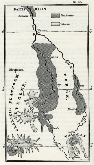
Earthquakes during the Eocene period. -- We have pointed out, in a former chapter, our reasons for concluding that the Paris basin was a theatre of subterranean convulsions during the Eocene period, the older beds of the calcaire grossier having been raised and exposed to the action of the waves before, or at least during, the deposition of the upper or second marine group. [9] These convulsions were doubtless connected with that depression which let in the sea upon the second freshwater formation, and gave rise to the superposition of the upper marine beds. We have also demonstrated, in a preceding chapter, that some of the earlier volcanic eruptions in Auvergne happened before the Eocene species of animals were extinct, and we suggested that the great lakes of Central France may have been drained by alterations of level which accompanied the outbreak of those earlier Eocene volcanos of Auvergne. We ought not, therefore, to be surprised if we discover proofs that the south-east of England participated in the earthquakes which seem to have extended at that time over a considerable part of the neighbouring continent; and we may refer the alternation of marine and fresh-water beds in the Isle of Wight and coast of Hampshire, to changes of level analogous to those which gave rise to the intercalation of the upper marine formation in the Paris basin.
Why the English Eocene strata rise nearly as high as the denuded secondary districts. -- Those geologists who have hitherto regarded the rise and denudation of the lands in the south-east of England as events posterior in date to the deposition of the London clay, will object to the foregoing reasoning, that not only certain outlying patches of tertiary strata, but even the central parts of the London and Hampshire basins, attain very considerable altitudes above the level of the sea. Thus the London clay at Highbeach, in Essex, reaches the height of 750 feet, an elevation exceeding that of large districts of the chalk and other denuded secondary rocks. But these facts do not, we think, militate against the theory above proposed, for we have assumed a long-continued series of elevatory movements in a region where the degradation and reproduction of strata were in progress.
If this be granted, it is evident that the great antagonist powers, the igneous and the aqueous, would, throughout the whole period, be brought into play in their fullest energy, the igneous labouring continually to produce the greatest inequality of surface, by uplifting certain lines of country and depressing others; the aqueous no less incessantly engaged in reducing the whole to a level, by cutting off the summits of the upraised tracts, and throwing the materials thence removed into the adjoining hollows. If the volcanic forces eventually prevail, so as to convert the whole region into land, we must expect that some of the materials drifted into the hollows, and forming the newer strata, will be brought up to view, while the denuded districts are raised at the same time. If these last continue, in general, to occupy a higher position above the level of the sea, it is all that can be expected after the levelling operations before alluded to.
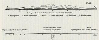
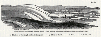
Now the tracts occupied by our Eocene formations are low, not so much with reference to the secondary rocks which remain, as to these masses which must be supposed by our theory to have disappeared, having been carried away by denudation. Let the portions removed from the space intervening between the North and South Downs, and which are expressed by faint lines in our section, wood- cut No. 63, be restored, and we may readily conceive that those masses may have formed shoals and dry land for ages before any part of our tertiary basins emerged.
The estimate of Mr. Martin is not, perhaps, exaggerated, when he computes the probable thickness of strata removed from the highest part of the Forest ridge to be about 1900 feet. So that if we restore to Crowborough Hill, in Sussex, the beds of Weald clay, Lower green-sand, Gault, and chalk, which have been removed by denudation, that hill, instead of rising to the height of 800 feet, would be more than trebled in altitude, [10] and be about 2700 feet high. It would then tower far above the highest outlyers of tertiary strata which are scattered over our chalk, for Inkpen Hill, the greatest elevation of chalk in England, rises only 1011 feet above the level of the sea.
Some geologists who have thought it necessary to suppose all the strata of the London and Hampshire basins to have been once continuous, have estimated the united thickness of the three marine Eocene groups before described, as amounting to 1300 feet, and have been bold enough to imagine a mass of this height to have been once superimposed upon the chalk which formerly covered the axis of the Weald. [11] Hence they were led to infer that Crowborough Hill was once 4000 feet high, and was then cut down from 4000 to 800 feet by diluvial action.
We, on the contrary, deem it wholly unnecessary to suppose any removal of rocks newer than the secondary from the central parts of the valley of the Weald; and we suppose the waste of the older rocks to have been caused gradually during the emergence of the country. The small strips of land which were first protruded in an open sea above the level of the waves, may have been entirely carried away, again and again, in the intervals between successive movements, until at last a great number of reefs and islands rising at once, afforded protection to each other against the attacks of the waves, and the lands began to increase. We do not conceive, therefore, that a mountain ridge first rose to the height of more than 2000 feet, and was then lowered to less than half that elevation; but that a stratified mass, more than 2000 feet thick, was, by the continual stripping off of the uppermost beds as they rose, diminished to a thickness of about 800 feet.
It is not our intention, at present, to point out the application of the above theory to the region immediately westward of the great line of chalk escarpment which runs through the central parts of England from Dorsetshire to Cambridgeshire. The denudation in that country has doubtless been on a great scale, and was, perhaps, effected during the Eocene period; for we know of no reason why one line of movements should not have been in progress in a direction north-east and southwest, while others were heaving up the strata in lines running east and west. We may remark, at the same time, that if the chalk in the interior of England, in those tracts from which it has been extensively swept away, began to rise during the tertiary epoch, and before the emergence of the chalk which once extended over the central axis of the Weald, some tertiary deposits may, in that case, have been thrown down upon that central ridge. We have at present, however, no data to lend countenance to such conjectures.
Vertical strata of the Isle of Wight. -- A line of vertical and inclined strata running east and west, or parallel to the central axis of the Weald, extends through the isles of Wight and Purbeck, and through Dorsetshire, and has been observed by Dr. Fitton to reappear in France, north of Dieppe. The same strata which are elevated in the Weald Valley are upheaved also on this line in the centre of the Isle of Wight, where all the tertiary strata appear to have partaken in the same movement. [12]
From the horizontality of the fresh-water series in Alum Bay, as contrasted with the vertical position of the marine tertiary beds, Mr. Webster was at first led very naturally to conclude, that the latter had undergone great derangement before the deposition of the former. It appears, however, from the subsequent observations of Professor Sedgwick, [13] that these appearances are deceptive, and that at the eastern extremity of the Isle of Wight, part of the fresh-water series is vertical, like the marine. Hence it is now ascertained that as the chalk is horizontal at the southern extremity of the Isle of Wight, while it is vertical in the centre of that island, so the Eocene strata are horizontal in the north of the island, and vertical in the centre. We have only to imagine that the great flexure of the secondary and tertiary beds, so ingeniously suggested by Mr. Webster in his theoretical section, [14] extended to the fresh-water formations, in order to comprehend how a very simple series of movements may have brought the whole of the Isle of Wight groups into their present position.
We are unable to assign a precise date to the convulsions which produced this great curve in the stratified rocks of the Isle of Wight; but we may observe that, although subsequent to the deposition of the fresh-water beds, it does not follow that it was not produced in the Eocene period. It may have been contemporaneous with those movements which raised the central parts of the London and Hampshire basins, which, as we before explained, were subsequent to the principal elevation and denudation of the central axis of the Weald.
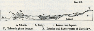
Land has certainly been elevated on our eastern coast since the commencement of the older Pliocene period, as is attested by the moderate height attained by the crag strata. [15] But these changes of level may have been partial, and if the crag does not extend farther over the Eocene formations, and into the Weald Valley, it is probably because those regions were dry land when the strata of crag were forming in the sea.
The first land that rose in the south-eastern extremity of England may have been placed, as we before hinted, where we now find the central axis of elevation in the Weald. Perhaps the chalk islands there formed may have supported that tropical vegetation whereof we find memorials in the fossil plants of Sheppey; and the shores of those islands may have been frequented, during the ovipositing season, by the turtles and crocodiles, of which the teeth and skeletons are imbedded in the London clay. [16]
Eocene alluviums. -- The river which produced that body of water in which the fresh-water strata of Hampshire originated, must have drained some contiguous lands which may have emerged during the Eocene period. On these lands we may suppose the Paleothere, Anoplothere, and Moschus of Binstead to have lived. The discovery of the two former genera, associated as they are with well-known Eocene species of testacea, is most interesting. It shows that in England, or rather on the space now occupied by part of our island, as well as in the Paris basin, Auvergne, Cantal, and Velay, there were mammalia of a peculiar type during the Eocene period. Yet we have never found a single fragment of the bones of any of these quadrupeds in our alluviums or cave breccias. In these formations we find the bones of the mastodon and mammoth, of the rhinoceros, hippopotamus, lion, hyaena, bear, and other quadrupeds, all of extinct species. They are accompanied by recent fresh-water shells, or by the marine fossils of the crag, and evidently belong to an epoch posterior to the Eocene. Where, then, are the terrestrial alluviums of that surface which was inhabited by the Paleothere and its congeners? Have the remains which were buried at so remote a period decomposed, so that they no longer afford any zoological characters which might enable us to distinguish the Eocene from more modern alluviums?
It seems clear that a peculiar and rare combination of favourable circumstances is required to preserve mammiferous or other remains in terrestrial alluviums in sufficient quantity to afford the geologist the means of assigning the date of such deposits. For this reason we are scarcely able, at present, to form any conjecture as to the relative ages of the numerous alluviums which cover the surface of Scotland, a country which probably became land long before the commencement of the tertiary epochs.
Elevation of land gradual. -- As we have assumed, throughout this and the preceding chapter, that the elevatory force was developed in a succession of minor convulsions in the southeast of England, we may seem called upon to answer an objection which has been drawn from the verticality of the strata in the Isles of Wight and Purbeck. Mr. Conybeare has remarked, that the vertical strata are traced through a district nearly 60 miles in length, so that 'if their present position were the effect of a single convulsion, no disturbance in the least comparable with it has occurred in modern times.' [17] As we can by no means dissent from this proposition, we only ask where is the evidence that a single effort of the subterranean force, rather than reiterated movements, produced that sharp flexure of which we suppose the vertical strata of the Isle of Wight to form a part, the remainder of the arc having been carried away by denudation.
It appears extremely probable that the Cutch earthquake of 1819, so often alluded to by us, [18] may have produced an incipient curve, running in a linear direction through a tract at least 60 miles in length. The strata were upraised in the Ullah Bund, and depressed below the level of the sea in the adjoining tract, where the fort of Sindree was submerged. It would be impossible, if the next earthquake should raise the Bund still higher, and sink to a lower depth the adjoining tract, to discriminate, by any geological investigations, the different effects of the two earthquakes, unless a minute survey of the effects of the first shock had been made and put on record. In this manner we may suppose the strata to be bent, again and again, in the course of future ages, until parts of them become perpendicular.
To some it may appear, that there is a unity of effect in the line of deranged strata in the isles of Wight and Purbeck, as also in the central axis of the Weald, which is inconsistent with the supposition of a great number of separate movements recurring after long intervals of time. But we know that earthquakes are repeated throughout a long series of ages, in the same spots, like volcanic eruptions. The oldest lavas of Etna were poured out many thousand, perhaps myriads, of years, before the newest, and yet they have produced a symmetrical mountain; and if rivers of melted matter thus continue to flow in the same direction, and towards the same points, for an indefinite lapse of ages, what difficulty is there in conceiving that the subterranean volcanic force, occasioning the rise or fall of certain parts of the earth's crust, may, by reiterated movements, produce the most perfect unity of result?
Excavation of Valleys. -- In our attempt to explain the origin of the existing valleys in the south-east of England, it will be seen that we refer their excavation chiefly to the ocean. We are aware that we cannot generalize these views and apply them to the valleys of all parts of the world. In Central France, for example, rivers and land-floods, co-operating with earthquakes, have deeply intersected the lacustrine and volcanic deposits, and have hollowed out valleys as deep, perhaps, as any in our Weald district. In what manner these effects may be brought about in the course of time, by the action of running water, even without the intervention of the sea, may be understood by what we have said of the removal of rock by aqueous agency during the Calabrian earthquakes. [19]
Those geologists who contend that the valleys in England are not due to what they term 'modern causes,' are in the habit of appealing to the fact, that the rivers in the interior of England are working no sensible alterations, and could never, in their present state, not even in millions of years, excavate the valleys through which they now flow. We suspect that a false theory is involved even in the term 'modern causes,' as if it could be assumed that there were ancient causes differing from those which are now in operation. But if we substitute the phrase, existing causes, we shall find that the argument now controverted amounts to little more than this, ' that in a country free from subterranean movements, the action of running water is so trifling that it could never hollow out, in any lapse of ages, a deep system of valleys, and, therefore, no known combination of existing causes could ever have given rise to our present valleys!?
The advocates of these doctrines, in their anxiety to point out the supposed absurdity of attributing to ordinary causes those inequalities of hill and dale, which now diversify the earth's surface, have too often kept entirely out of view the many recorded examples of elevations and subsidences of land during earthquakes, the frequent fissuring of mountains, and opening of chasms, the damming up of rivers by landslips, the deflection of streams from their original courses, and more important, perhaps, than all these, the denuding power of the ocean, during the rise of our continents from the deep. Few of the ordinary causes of change, whether igneous or aqueous, can be observed to act with their full intensity in anyone place at the same time; hence it is easy to persuade those who have not reflected long and profoundly on the working of the numerous igneous and aqueous agents, that they are entirely inadequate to bring about any important fluctuations in the configuration of the earth's surface.
Recapitulation. -- We shall now briefly recapitulate the conclusions to which we have arrived respecting the geology of the south-east of England, in reference to the nature and origin of the Eocene formations considered in this and the two preceding chapters.
1. In the first place, it appears that the tertiary strata rest exclusively upon the chalk, and consist, with some trifling exceptions, of alternations of clay and sand.
2. The organic remains agree with those of the Paris basin, but the mineral character of the deposit is extremely different, those rocks in particular, which are common to the Paris basin and Central France, being wanting, or extremely rare, in the English tertiary formations.
3. The Eocene deposits of England are generally conformable to the chalk, being horizontal where the beds of chalk are horizontal, and vertical where they are vertical; so that both series of rocks appear to have participated in nearly the same movements.
4. It is not possible to define the limits of the ancient borders of the tertiary sea in the south-east of England, in the same manner as can be frequently done in those countries where the secondary rocks are unconformable to the tertiary.
5. Although the tertiary deposits are chiefly confined to the tracts called the basins of London and Hampshire, insulated patches of them are, nevertheless, found on some of the highest summits of the chalk intervening between these basins.
6. These outliers, however, do not necessarily prove that the great mass of tertiary strata was once continuous between the basins of London and Hampshire, and over other parts of the south-east of England now occupied by secondary rocks.
7. On the contrary, it is probable that these secondary districts were gradually elevated and denuded when the basins of London and Hampshire were still submarine, and while they were gradually becoming filled up with tertiary sand and clay.
8. If, in illustration of this theory, we examine one of the districts thus supposed to have been denuded, we find in the Valley of the Weald decided proofs, that since the emergence of the secondary rocks, an immense mass of chalk and subjacent formations has been removed by the force of water.
9. We infer from the existence of large valleys along the outcrop of the softer beds, and of parallel chains of hills where harder rocks come up to the surface, that water was the removing cause; and from the shape of the escarpments presented by the harder rocks, and the distribution of alluvium over different parts of the surface of the Weald district, we conclude that the denudation was successive and gradual during the rise of the strata.
10. We may suppose that the materials carried away from the denuded district were conveyed into the depths of the contiguous sea, through channels produced by cross fractures which have since become river-channels, and which now intersect the chalk in a direction at right angles to the general axis of elevation of the country.
11. The analogous structure of the Valley of Kingsclere, and other valleys which run east and west, like the Valley of the Weald, but are much narrower, accord also with the hypothesis, that they were all produced by the denuding power of water co-operating with elevatory movements.
12. The mineral composition of the materials thus supposed to have been removed in immense abundance from the Valley of the Weald, are precisely such as would, by degradation, form the English Eocene strata.
13. It is probable that there were many oscillations of level during the Eocene period, so that some tracts were alternately land and then sea, and then land again. These fluctuations may account for the furrowed surface of the chalk on which the tertiary strata sometimes repose, for the valleys on its surface, for the banks of shingle associated with the Plastic clay, for the partial deposits of sand and clay on elevated tracts of chalk, and for the alternations of marine and fresh-water strata in the Hampshire basin.
14. The volcanic eruptions of the Eocene period in Auvergne, the changes of level which took place at the same time in the Paris basin, and those above alluded to in the south-east of England, may all have belonged to one theatre of subterranean convulsion.
15. The basins of London and Hampshire may have been partly formed by subsidences in the bed of the sea, contemporaneously with the elevation and emergence of the Weald district.
16. The movements which threw the chalk and the tertiary strata of the isles of Wight and Purbeck into a vertical position, were subsequent to the formation of the Eocene freshwater strata of the Isle of Wight, but may possibly have occurred during the Eocene period.
17. The masses of secondary rock which have been removed by denudation from the central axis of the Weald would, if restored, rise to more than double the height now attained by any patches of tertiary strata in England.
18. If, therefore, the Eocene strata do not appear to occupy a much lower level than the secondary rocks, from the destruction of which they have been formed, it is because the highest summits of the latter have been cut off during the rise of the land, and thrown into those troughs where we now find the tertiary deposits.
19. The upheaving of the strata of the London and Hampshire basins may have been in great part effected towards the close of the Eocene period; but it must also have been in some part due to the movements which raised the crag.
_______________
Notes:1. Outlines, p. 144.
2. See above, p. 295.
3. Geol. Trans., 2nd Series, vol. ii. p. 119.
4. Copied by permission from Dr. Buckland's plate XVII., Geol. Trans., 2nd Series, vol. ii.
5. See Mr. Murchison's map, plate XIV., ibid.
6. Dr. Buckland, Geol. Trans., 2nd Series, vol. ii. p. 122.
7. Dr. Buckland, Geol. Trans., 2nd Series, vol. ii. p. 123.
8. Vol. i. p. 279, and Second Edition, p. 319.
9. See above, p. 248.
10. Phil. Mag. and Annals, No. 26, New Series, p. 117.
11. Martin, ibid.
12. See Mr. Webster's section, Geol. Trans., vol. ii. First Series, plate XI.
13. Anniv. Address to the Geol. Soc., Feb. 1831, p. 9. Professor Sedgwick informs me that his observations, made six years ago, have recently been confirmed by Professor Henslow.
14. Englefield's Isle of Wight, plate XLVII. fig. I.
15. We alluded, at p. 182, to the supposed discovery of recent marine shells at the height of 140 feet above the sea in Sheppey; but we have since learnt from Professor Sedgwick, that the information communicated to the Geological Society on this subject was erroneous.
16. We have introduced these islands into the map of Europe, in the 2nd volume, which may be supposed to relate to the commencement of the Eocene period.
17. Phil. Mag. and Annals, No. 49, new Series, p. 21.
18. Vol. i., Second Edition, p. 465, and vol. ii., First Edition, p. 265.
19. Vol. i. chap. xxiv.